
On the stone (mountain)
| On the stone | ||
|---|---|---|
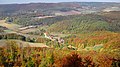
 View from the Dieteröder cliffs to the stone |
||
| height | 496.1 m | |
| location | Eichsfeld district , northwest Thuringia | |
| Mountains | Gobert , Thuringian Basin (with edge plates) | |
| Coordinates | 51 ° 17 '24 " N , 10 ° 2' 7" E | |
|
||
| Type | Zeugenberg | |
| rock | Shell limestone | |

On the stone , also just called stone , is a 496.1 m high mountain in the west of the Eichsfeld district in Thuringia ( Germany ).
geography
location
The mountain is located in the western part of the Eichsfeld district near the state border with Hesse . Viewed clockwise, it lies between the small towns of Asbach-Sickenberg in the south and south-west, Dietzenrode-Vatterode in the west and north-west, Mackenrode and Henningerode in the north-east. The closest cities are Bad Sooden-Allendorf (Hesse) (4 kilometers to the southwest) and Heilbad Heiligenstadt ( Thuringia ) (about 12 km to the northeast).
The Wanfried Agreement in 1945 resulted in a shift in the American-Soviet zone border and thus the later Thuringian-Hessian state border. So the places Asbach-Sickenberg , Vatterode , Weidenbach and the associated mountain came to Thuringia . The mountain does not belong to the historical Eichsfeld . The inner German border ran south of the mountain and can still be viewed at the Schifflersgrund border museum near Asbach-Sickenberg.
Natural allocation
According to the natural structure in the Kassel sheet, the mountain is one of the northern foothills of the Gobert (No. 483.10), part of the north-western edge of the Thuringian Basin (No. 483). According to the structure within Thuringia ( The Natural Spaces of Thuringia ), it is assigned to the Werrabergland-Hörselberge unit.
nature
The most south-westerly and highest elevation of the small mountain plateau Auf dem Stein is the Dietzenröder Stein . Immediately on its western edge there is a rock wall made of shell limestone , the so-called Dietzenröder cliffs . A narrow mountain spur runs to the south-east, Die Nase (approx. 450 m ) and to the north-west is the Vatteröder Stein (approx. 465 m ), both also with a small rock face. From all three points you have a wonderful view of the Werra valley and the adjoining mountainous region in western Eichsfeld and northeastern Hesse .
The mountain is mostly covered with deciduous forest and belongs to the Allendorfer Stadtwald . The most common tree species is the beech , but there are also some stands of yew . At the foot of the mountain at the transition to the Buntsandstein there are further foothills and mountain peaks such as the Lindenberg ( 393.5 m ), Scharfenberg ( 375.6 m ) and Heiligenberg ( 310.9 m ). To the northeast it borders directly on the Eichenberg – Gotha – Saalfeld fault zone . Numerous hiking trails lead from the surrounding villages into the mountain area.

View from the direction of Fretterode to the Vatteröder stone
View from Vatteröder Stein to Vatterode in the Walsetal

Yew trees under the protective beech forest


Individual evidence
- ^ Measurement table sheet Kurfürstenthum Hessen, sheet 26: Asbach, 1857
- ↑ In most recent maps neither the name of the mountain nor the mountain height is recorded. Only a few maps, such as the BfN map service (1: 10000), provide name and altitude information.
- ↑ Franz Neureuter: Das Eichsfeld, Volume 1: The landscapes of the Eichsfeld Aloys Mecke Duderstadt, 1933, page 106
- ↑ Map services of the Federal Agency for Nature Conservation ( information )
- ↑ Hans-Jürgen Klink: Geographical land survey: The natural space units on sheet 112 Kassel - Federal Institute for Regional Studies, Bad Godesberg 1969 → online map