
Bévéra
at Saint-Jouie at 536 m
|
Bévéra Bevera / Beura |
||
 The Bévéra in Sospel |
||
| Data | ||
| Water code | FR : Y6630500 | |
| location | France , Provence-Alpes-Cote d'Azur region and Italy , Liguria region | |
| River system | Roya | |
| Drain over | Roya → Ligurian Sea | |
| source | on the municipal boundary of Moulinet and Breil-sur-Roya 43 ° 59 ′ 37 ″ N , 7 ° 25 ′ 56 ″ E |
|
| Source height | approx. 1990 m | |
| muzzle | in the municipality of Ventimiglia in the Roya coordinates: 43 ° 49 ′ 23 " N , 7 ° 35 ′ 2" E 43 ° 49 ′ 23 " N , 7 ° 35 ′ 2" E |
|
| Mouth height | approx. 21 m slm | |
| Height difference | approx. 1969 m | |
| Bottom slope | approx. 46 ‰ | |
| length | 43 km | |
| Catchment area | 130.83 km² | |
| Runoff at the gauge near Sospel |
MQ |
1.03 m³ / s |
| Left tributaries | see adjacent table | |
| Right tributaries | see adjacent table | |
 In the same place in spring |
||
The Bévéra ( Italian : Bevera , Occitan and Ligurian : Beura) is a 38 km long tributary of the Roya , which in the French department of Alpes-Maritimes in the region d'Provence-Alpes-Cote Azur and in the Italian province of Imperia in the region Liguria runs and drains an area of around 131 square kilometers.
course
The Bévéra rises in the Mercantour National Park on the Authion massif ( 2078 m ), just a few kilometers northeast of the Col de Turini , on the municipal boundary of Moulinet and Breil-sur-Roya . It flows south and touches the center of Moulinet. At Sospel it changes its course to the east, flows through the outermost part of the municipality of Breil-sur-Roya for a short distance and crosses the border to Italy after 27 kilometers at Olivetta San Michele . The Bévéra now keeps to the south-east and meanders past a partially uninhabited, wooded valley. It flows through the municipality of Airole and flows into the Roya at Bevera (municipality of Ventimiglia ) at 21 m slm as a right tributary, which flows into the Ligurian Sea a little later .
Tributaries
|
In France:
|
In Italy:
|
free time activities
The river is used for canyoning and fishing, the surrounding valley for hiking.
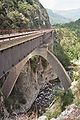
Bévéra Viaduct of the Tenda Railway in France

See also
- List of French Mediterranean tributaries and their tributaries, from 36 km in length, sorted geographically
Web links
Individual evidence
- ↑ Source geoportail.gouv.fr
- ↑ estuary geoportail.gouv.fr
- ↑ Checking the length of the French section with measurement function from https://www.geoportail.gouv.fr/carte showed between 26.4 km and 26.7 km. Then checks using GPSies tracks: Frazione_italiana_del_fiume_Bevera = 16.7 km and Bévêra –- Bevera_total = 42.94 km. The French part would be only 16.4 km long. The total length determined by GPSies is therefore rather too short than too long.
- ↑ catchment area on observatoire-eau-paca.org
- ↑ drain hydro.eaufrance.fr