
Barbarossa spring
| Barbarossa spring | ||||
|---|---|---|---|---|
 Barbarossa spring |
||||
| location | ||||
| Country or region | Main-Kinzig district ( Hesse ) | |||
| Coordinates | 50 ° 7 '13 " N , 9 ° 3' 11" E | |||
| height | 167 m above sea level NHN | |||
|
||||
| geology | ||||
| Mountains | Spessart | |||
| rock | Sandstone | |||
| Hydrology | ||||
| River system | Rhine | |||

Coordinates: 50 ° 7 ′ 13 ″ N , 9 ° 3 ′ 11 ″ E
The Barbarossa spring is a small spring near Rodenbach in Vor Spessart in the Main-Kinzig district in Hesse .
geography

The source is located in the southeastern Bulau , a larger contiguous forest area east of Hanau . The Barbarossa spring is located in a small basin on the edge of a forest lake, near the border between the Hessian Oberrodenbach and the Bavarian Alzenau , at an altitude of 167 m above sea level. NN . The name Barbarossaquelle does not refer to the lake, as many believed, but to the small spring next to it.
source

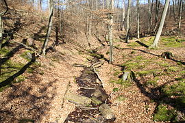
The constantly pouring spring is located south of the forest lake, about five meters from the shore. In 1970 it was fitted with a drainage pipe and set in a granite gneiss wall. The water springs from the clay and sandstones of the Red Lying Permian . The spring takes its name from Friedrich I , Barbarossa, who often stopped at the spring on his hunting expeditions from the Barbarossa town of Gelnhausen to the Bulau. The spring water temperature averages 11.7 ° C and has increased by 1.9 ° C since the 1960s.
Forest lake

The approximately 0.5 hectare lake is now dammed by a dam built in 1950. This was built to make the water suitable for fishing . However, due to the creation of a biotope , this use was not realized. In 1970 the lake was cleaned and dredged. In doing so, its original depth of 5 meters was restored. However, due to silting, a depth of at most 1.5 m was assumed in 2012. A small trail leads around the lake as a circular route. There is a barbecue area on the shore .
The Waldsee has two natural tributaries from the east, which arise on the western slopes of the Altenmarkskopf (269 m). These do not have an official name, but were popularly named after the builders of the small wooden bridges on the lake, Peter and Paul. The north-eastern, more water-rich inlet is about 1.2 km long and runs along the asphalt access road to the Waldsee. The southeastern one has a length of about 400 m. The flowing stream is formed from these two streams and the water of the Barbarossa spring. It escapes the lake in a westerly direction and runs through a clearing , the official meadow . The stream becomes smaller on the sandy bottom of Bulau until it finally km for a flow distance of about 1.5, already on the district of Hanau-Wolfgang , in the side groove of the Birkenhainer road immediately, completely at the Bavarian border seeps .
A similar stream in the Bulau is the Einfallsgraben which the Klappermühlchen fed. Like the brook of the Barbarossa spring, it seeps away after only a few kilometers in the Alzenau city forest. The sandy construction soil also causes problems for the stream at the Antoniusgrotte in Alzenau north of the 2305 state road . He too will never reach his goal above ground.
Flora and fauna
In the forest lake of the Barbarossa spring water lilies grow in some places . You can also see some fish and amphibian species in the water. Dragonflies also feel good at the Waldsee.
Picture gallery
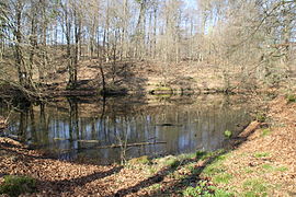
The forest lake in spring 2016
Northeast inlet of the lake

South-eastern inlet of the lake

Drainage of the lake


Web links
Individual evidence
- ↑ a b Our Kahlgrund 2012 . Homeland yearbook for the Alzenau district. Published by the working group for homeland research and homeland maintenance of the Alzenau district, district administrator. ISSN 0933-1328 .
- ^ Hessian State Office for Environment and Geology
- ↑ Barbarossa spring in the source atlas (pdf)
- ^ Annual report 2008 of the State Groundwater Service Hessen