
Boucle du Mouhoun
| Basic data | |
|---|---|
| Capital : | Dédougou |
| Provinces : | 6th |
| Governor : | Temaï Pascal Benon |
| Area : | 34,479 km² |
| Residents : | 1,434,847 |
| Bev density: | 41.6 inhabitants / km² |
| ISO 3166-2 : | BF-01 |
| location | |
  |
|
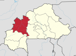
Boucle du Mouhoun is one of 13 regions into which the West African state of Burkina Faso is administratively divided. The capital is Dédougou . The region to the west includes the provinces of Balé , Banwa , Kossi , Mouhoun , Nayala and Sourou and is bordered by Center-Ouest to the east, Hauts-Bassins to the south , the north-east to the north and the state of Mali to the west .
1,434,847 inhabitants (2006 census) live on 34,479 km², mainly Sanan and Bwaba , most of whom are of Islamic faith.
| province | Capital | Population (2006 Census) |
|---|---|---|
| Balé | Boromo | 213,897 |
| Banwa | Solenzo | 267.934 |
| Kossi | Nouna | 272.223 |
| Mouhoun (province) | Dédougou | 298.008 |
| Nayala | Toma | 162,869 |
| Sourou | Tougan | 219,826 |
The gold mines in Boucle du Mouhoun are the most important in Burkina Faso, and there are also deposits of diamonds and bauxite . The region is hardly industrialized, the majority of the population operates subsistence agriculture .
Individual evidence
- ↑ 2006 Census ( Memento of the original from September 27, 2007 in the Internet Archive ) Info: The archive link was inserted automatically and has not yet been checked. Please check the original and archive link according to the instructions and then remove this notice.
- ↑ National 2006 census preliminary results [1] (PDF; 3.3 MB)
Boucle du Mouhoun | Cascades | Center | Center-Est | Center-North | Center-Ouest | Center-Sud | Est | Hauts-Basins | North | Plateau Central | Sahel | Sud-Ouest