Brahmani
| Brahmani | ||
|
Lower Brahmani |
||
| Data | ||
| location | Odisha ( India ) | |
| River system | Brahmani | |
| Confluence of |
Koel and Sankh 22 ° 14 '12 " N , 84 ° 47' 58" O |
|
| Source height | approx. 200 m | |
| muzzle |
Gulf of Bengal Coordinates: 20 ° 46 ′ 44 " N , 86 ° 57 ′ 56" E 20 ° 46 ′ 44 " N , 86 ° 57 ′ 56" E |
|
| Mouth height | 0 m | |
| Height difference | approx. 200 m | |
| Bottom slope | approx. 0.44 ‰ | |
| length | approx. 450 km | |
| Catchment area | 39,116 km² (excluding Baitarani) | |
| Left tributaries | Samakoi, Ramiala, Baitarani | |
| Right tributaries | Gohira, Tikera | |
| Reservoirs flowed through | Rengali dam , Samal barrage | |
| Big cities | Rourkela | |
| Medium-sized cities | Talcher , Pattamundai | |
The Brahmani is a river in the east of India in the state of Odisha , which flows into the Bay of Bengal .
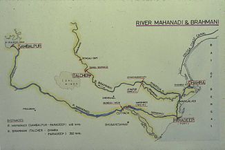
The Brahmani does not have water all year round. It arises near Rourkela at the confluence of its two source rivers Koel (left) and Sankh (right). It then flows south through the Eastern Ghats . It is dammed up by the Rengali dam . Above the town of Talcher lies the Samal barrage on the Brahmani. An irrigation channel branches off on both sides . The river passes the town of Talcher and later turns east. The Mahanadi runs south of the lower reaches of the Brahmani. In the lowlands, the Brahmani splits into several river arms (including the 85 km long northern arm of the river Kharsua ), some of which unite again. The city of Pattamundai is located on the southernmost arm of the river . The Baitarani meets the northernmost arm of the Brahmani 20 km above the mouth.
The Brahmani has a length of about 450 km. It drains an area of 39,116 km², not including the catchment area of the Baitarani. Of these, 22,516 km² are in Odisha, 15,700 km² in Jharkhand and around 900 km² in Chhattisgarh . Important tributaries are: Gohira, Tikera, Samakoi and Ramiala.
