Breithardt
|
Breithardt
Community Hohenstein
|
|
|---|---|
| Coordinates: 50 ° 11 '43 " N , 8 ° 5' 51" E | |
| Height : | 290 m above sea level NHN |
| Area : | 11.5 km² |
| Residents : | 1696 (June 30, 2017) |
| Population density : | 147 inhabitants / km² |
| Incorporation : | July 1, 1972 |
| Postal code : | 65329 |
| Area code : | 06120 |
With around 1700 inhabitants, Breithardt is the largest district and the seat of the municipality of Hohenstein in the Rheingau-Taunus district in southern Hesse .
geography
Breithardt is located in the western Hintertaunus on the Breitharder Bach , a right eastern tributary of the Aar , about two kilometers away from it. The Aartal forms the western boundary, the route of the Upper German-Raetian Limes roughly the southern and the ridge on which the Eisenstrasse runs, the eastern boundary. The district area is 1148 hectares, 517 hectares of which are forested, mainly in the west and south. The lowest point of the district is at the entrance of the Breithardter Bach into the Aartal at around 250 meters and the highest point at 414.8 meters is the wooded Frankenberg above the Aartal.
history
The village was first mentioned around 1260 as "Bretterthe" and is now also known colloquially as "Braadert". The current form of the name has been around since 1648. Breithardt means something like “wide forest” or “widely built-up land”.
On March 10, 1418 Breithardt received city rights at the Council of Constance . The Swedes invaded Breithardt on January 25, 1635 and killed four Breithardts. On March 28, 1945, Breithardt was liberated by the American army at the end of World War II .
On July 1, 1972, the municipalities of Breithardt, Born, Hohenstein (later Burg-Hohenstein), Hennethal, Holzhausen via Aar, Steckenroth and Strinz-Margarethä merged to form the municipality of Hohenstein (Untertaunus) on a voluntary basis as part of the regional reform in Hesse . For Breithardt, as for the other districts, a local district with a local advisory board and local councilor was established.
coat of arms
On March 20, 1968, the municipality of Breithardt in the then Untertaunuskreis was awarded a coat of arms with the following blazon : In gold, a black double cross, underscored by a blue shield with a growing, golden, red-armored half lion.
Culture and sights
Buildings
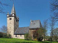
- Evangelical Church Breithardt
- The old castle is a presumed castle stable
Regular events
Every 4th Sunday in October, the people of Breithard celebrate the so-called "Braaderter Curb", which is known to have been held for the first time in 1532.
traffic
Breithardt has a stop at the Aartalbahn , which is about 2 km west of the village. Since 1986 only museum trains have been running there.
Sons and daughters of the place
- Heinz Hankammer (1931–2016), entrepreneur and club official
Web links
- District Breithardt on the website of the community Hohenstein.
- Breithardt, Rheingau-Taunus-Kreis. Historical local dictionary for Hessen. In: Landesgeschichtliches Informationssystem Hessen (LAGIS).
- Literature on Breithardt in the Hessian Bibliography
Individual evidence
- ↑ a b Statistics of the Hohenstein community: areas and population figures , accessed in September 2018.
- ^ Municipal reform in Hesse: mergers and integrations of municipalities from June 21, 1972 . In: The Hessian Minister of the Interior (ed.): State Gazette for the State of Hesse. 1972 No. 28 , p. 1197 , point 851 para. 6. ( Online at the information system of the Hessian State Parliament [PDF; 4.4 MB ]).
- ^ Federal Statistical Office (ed.): Historical municipality directory for the Federal Republic of Germany. Name, border and key number changes in municipalities, counties and administrative districts from May 27, 1970 to December 31, 1982 . W. Kohlhammer, Stuttgart / Mainz 1983, ISBN 3-17-003263-1 , p. 378 .
- ↑ main statute. (PDF; 22 kB) § 6. In: Website. Hohenstein community, accessed February 2019 .
- ↑ Approval of a coat of arms and a flag for the community of Breithardt, Untertaunuskreis, Wiesbaden administrative district of March 20, 1968 . In: The Hessian Minister of the Interior (ed.): State Gazette for the State of Hesse. 1968 No. 15 , p. 610 , point 458 ( online at the information system of the Hessian state parliament [PDF; 4.0 MB ]).


