
Bubastis Canal

The in antiquity scale Canal of the Pharaohs (also Ismailia Canal ) is considered the precursor of the Suez Canal , although he had a different course: from Bubastis in the eastern Nile delta (today Zagazig ) east through the Wadi Tumilat the lake timsah and thence southwards into the Red Sea . What they have in common with the Suez Canal is the function of a navigable connection to the Red Sea, in which the Egyptians living on the Nile and the Nile Delta were more interested than in a connection between the Mediterranean and the Red Sea.
Today's Ismailia Canal between Cairo and Ismailia is a successor to the Bubastis Canal. Since the Suez Canal was built, it has been used to supply water to the towns on the Suez Canal and along this canal.
Canal construction in ancient Egypt
Canal in the Middle or New Kingdom?
There is said to have been a smaller canal north of the later Bubastis Canal, which, however, probably did not lead to the Red Sea. However, there is apparently no ancient Egyptian evidence that clearly proves this channel. From the information provided by Aristotle , Strabo and Pliny the Elder , some deduce that the canal was built in the time of Pharaoh Sesostris I (1956 to 1910 BC). Others write the construction of the canal or the removal of silting up in the meantime to Pharaoh Sesostris III. (1878 to 1839 BC) or Seti I (1290 to 1279 BC) and Ramses II (1279 to 1213 BC). The reasons why the canal was probably not led into the Red Sea are, on the one hand, the opinion that was apparently widespread at the time that the water level of the Red Sea was higher than the Nile Delta and therefore the Nile Delta would be flooded, on the other hand the fear that Even at the same level, salt water could penetrate the canal system and thereby damage irrigation.
Canal of Necho II in the Late Period
The construction of the canal by Necho II (610 to 595 BC) from Bubastis through the Wadi Tumilat , reported by Herodotus , is probably undisputed. However, Necho II probably did not complete the canal either, according to Herodotus because of an unfavorable oracle, but in fact probably because of a war with the Babylonians under Nebuchadnezzar II.
Psammetich I , the father and predecessor of Nechos, had already set up a Greek mercenary fleet and promoted Greek trade in his empire. Necho II intensified these maritime efforts.
Herodotus wrote about the channel:
“The son of Psammetichos was Nekos ( Necho II ); he succeeded his father on the throne. He was the first to start building the canal into the Red Sea, which the Persian Darius later completed. The length (of the canal) corresponds to a journey of four days. Its width has been raised so that two three-rowers can drive next to each other with their oars extended. He gets his water from the Nile. The canal begins a little above the city of Bubastis and leads past the Arab city of Patumos into the Red Sea. It was first excavated on the parts of the Egyptian plain that point to Arabia and above which are the mountains that extend to the vicinity of Memphis , where the quarries are located. At the foot of these mountains the canal runs a long stretch from west to east; then he turns to a cut in the hills and strives from these mountains to the south and against the south wind towards the Arabian Gulf. Well, at the shortest and narrowest point between the northern and the southern sea, also known as the Red Sea, from Mount Kasion, which forms the border between Egypt and Syria, the distance to the Arabian Gulf is exactly 1,000 stadia . It's the shortest way. But the moat is much longer with its many curves; and during the reign of Nekos, 12,000 Egyptians died building the canal. Well, in the middle of his work, Nekos stopped because an oracle advised him against: what he was building was preparatory work for the barbarians. The Egyptians understand barbarians as all peoples who do not speak their language. So after he stopped working, Nekos began fierce wars. He had three-oars built, some for the northern sea and others in the Arabian Gulf for the Red Sea; and you can still see the construction huts. "
A little later, Herodotus writes about the Arabian Peninsula that it ends at the Arabian Gulf, into which Darius led the channel from the Nile, but mentions it elsewhere in connection with the continent of Africa: As the construction of the channel from the Nile to the Arabian Gulf should lead, was ready, he sent Phoenicians to circling Africa, starting from the channel, clockwise. From this it could be concluded that Herodotus wrote of the completion of the canal already under Necho II as a prerequisite for circumnavigating Africa and that he contradicts himself.
The number of dead in canal construction given by Herodotus is probably one of his frequent exaggerations.
Channel of Darius I.
Darius I (521 to 486 BC) renewed this canal and led it to the Red Sea. As a reminder, he had four steles set up, including that of Kabret with the inscription:
“King Darius says: I am a Persian. From Persia I conquered Egypt. I ordered this channel to be dug from the river called the Nile in Egypt to the sea that begins in Persia. When this channel was dug as I ordered, ships sailed from Egypt to Persia, as I wanted. "
The four steles discovered during the construction of the Suez Canal stood (1) in the place of Necho II at the end of the seventh century BC. Newly founded Pitom (Heroonpolis), (2) between Timsah and Great Bitter Lakes near Serapeum, (3) near Kabret near the southern end of the Great Bitter Lake and (4) about 6 km north of Suez.
It is not known how long the Darius I Canal was used. After the collapse of the Persian Empire , the not easy to navigate sea route along the largely empty Arabian coast to Persia became uninteresting; the route must have been forgotten. At the time of Alexander the Great , circumnavigating Arabia was again considered impracticable because of the heat and the desert. The trade was again on the caravan routes .
Ptolemaic Canal
Under Ptolemy II Philadelphos (284 to 246 BC) the Ptolemies renewed the canal and built locks at the confluence with the Gulf of Suez to prevent salt water from entering. This Ptolemaic canal is said to have been led from the Pelusian arm of the Nile near the city of Daphne across the El Ferdan plain to Lake Timsah, where it met the old Pharaoh's canal , which had to be re-dug. This canal construction seems to be reported in the poorly preserved and barely legible pithome stele named after its place of discovery . At the mouth of the channel into the Red Sea, the place Arsinoë was created, named after Arsinoë Philadelphos, the second wife and biological sister of Ptolemy II. The exact location of this place does not seem to be known. In the maps that were made by Napoleon's engineers during his Egyptian expedition and reproduced in the Description de l'Égypte , the ruins of Arsinoë and Cleopatris are drawn on a small hill north of the shallow bay in which the Gulf of Suez ended . Neither the hill nor the bay are recognizable today.
At the time of Cleopatra VII (69 to 30 BC) the Pelusian branch of the Nile had migrated to the west and was no longer usable as a waterway, so that there was no longer a canal connection.
Trajan Canal
Under Emperor Trajan , work on the canal was resumed around 100 AD and a new connecting canal was built from today's Cairo ( Babylon ) via Bilbeis to the old Bubastis canal, which is known as Amnis Trajanus or Amnis Augustus . Opposite the Ptolemaic city of Arsinoë, Trajan built the fortified port of Klysma ( Cleopatris , later Kolzum ). The location of this place cannot be precisely determined today either. In one of the Napoleonic maps, however, Kolzum is drawn immediately northwest of the former Suez and would therefore be in the urban area of Suez today. With the Trajan Canal, a direct ship connection to the eastern Roman province of Arabia Petraea was created to simplify the transport of goods. This canal was also maintained under Emperor Hadrian (117-138 AD). At the time of the death of Emperor Trajan in 117 AD, Rome ruled all the ports of the Red Sea and the Persian Gulf. Trade from Egypt to the south and east had reached its peak. With this began the direct prehistory of the later Suez Canal.
In the 3rd century the economic situation deteriorated. The long-distance trade with India and China became more and more of the Sassanian taken. The canal became less important, but has been maintained. It is assumed that the canal was still navigable at the beginning of the rule of the Arabs, at least during the floods of the Nile, others believe that it was already silted up at that time.
Arab channel
Amr ibn al-As , a commander of Mohammed who ruled Egypt from 641 to 644 AD, had the canal restored to supply the Arab sites with grain and as a transport route for the pilgrims.
However, Al-Mansur , the second Abbasid caliph , is said to have ordered the closure of the canal in 770 as a measure against his enemies in Medina.
background
geography
In ancient Egypt, the most easterly, the Pelusische branch of the Nile from today led Cairo to the east, beyond the present-day Port Said located Pelusium . The Wadi Tumilat, which is clearly recognizable on today's satellite images, leads from Bubastis, located on this Pelusian branch of the Nile, to Lake Timsah. The Wadi Tumilat is largely flat and is now 5.5 to 6.5 m above sea level. There appears to have been a lake in the western part of Wadi Tumilat. From the Timsahsee it is only a few kilometers to the bitter lakes to the south of it , which in turn are only a few kilometers north of today's Suez .
Wadi Tumilat was a large river bed in geological times. It seems to have got its present form after the last Ice Age and has been around since around 3000 BC. Not to have changed significantly any more. At the end of the Old Kingdom , the dry wadi was repeatedly inundated by floods of the Nile. During the Middle Kingdom , on the other hand, there were high floods of the Nile, which only subsided in the New Kingdom during the 20th Dynasty. During the late period from approx. 600 BC There were obviously high Nile floods again, which forced the inhabitants of the wadi to higher areas. Shortly after the Ptolemaic or Greco-Roman times , the wadi was probably abandoned.
The Nile thus had a natural runoff through the Wadi Tumilat, at least during the Nile floods. Also in 1860 AD there was still a flood of the Nile through Wadi Tumilat to Lake Timsah.
It seems unclear whether and when the bitter lakes were part of the Red Sea and were only separated from it by raising a section north of Suez. This increase took place in prehistoric times, according to another opinion only in antiquity. In the map below from 1857, it is noted, without any further details, that the bitter lakes used to be part of the Red Sea. The map of Egypt, New Kingdom in Putzger's historical school atlas from 1917 also shows a gulf reaching into the bitter lakes with a connection to Wadi Tumilat. However, this information comes from a time when plate tectonics was still unknown. The steles of Darius I lead to the assumption that they mark the canal built by him, which therefore went until shortly before Suez. Such a stele is unlikely to have been erected on the bank of a navigable arm of the sea, unless the connection to the bitter lakes was so flat that this flat tongue of the sea also had to be dredged. The maps from Napoleon's Egyptian expedition mentioned above show traces of the old Suez Canal ( Vestiges de l'ancien Canal de Suez ), which begin directly at the Gulf of Suez and end on the southern bank of the bitter lakes. Start or east of Bubastis and lead across the entire Wadi Tumilat.
Lengths and other dimensions
The following length specifications for the duct sections are approximate, but by no means exact duct lengths.
| Bubastis - Ismailia | 72 km |
| Bubastis - Suez | 160 km |
| Cairo - Bilbeis | 50 km |
| Cairo - Ismailia | 128 km |
| Cairo - Suez | 210 km |
According to Pliny the Elder Ä. the channel is said to have been 100 feet wide and 30 feet deep and 37 ½ miles in length to the bitter lakes and 62 ½ miles from the delta to the Red Sea. This would result in a width of 35 m, a depth of 10 m and lengths of 55.6 km to the Bitter Lake and 92.6 km to the Red Sea.
Pliny 's length specifications seem to make little sense. The depth of 10 m is illusory. The original Suez Canal was only 8 m deep. No canal is built deeper than necessary for shipping. The draft of the ships at that time is likely to have been well below 2 m. The width would correspond to Herodotus' information that two triremes could pass each other if the fuselage was set at almost 5 m and for the oars with a safety distance of 5 m on both sides.
Structural considerations
The Nile Delta consists of alluvial land several meters deep, mixed with sand, which can be excavated relatively easily in dry conditions. Between Ismailia and the bitter lakes, the subsoil consists largely of sand, while in the area between the bitter lakes and Suez rocks mixed with sand can be found. This also raises doubts that the bitter lakes were part of the Gulf in recent times. If they weren't, they had a significantly lower water level than the Red Sea due to the high level of evaporation and, as the name already suggests, salty water due to the lack of a drain. The canal builders will therefore have their fresh water canal fed by the Nile (just like today's fresh water canal) along the bitter lakes and not through them (like today's salt water canal). It would not have been possible with the means at the time to prevent salt from entering the freshwater canal.
The slope of the current Suez Canal is 4: 1. In the silt of Wadi Tumilat, steeper slopes might be possible, which of course wash out and slide much faster and therefore require more maintenance. However, a slope of 2: 1 should not be possible.
Assuming (with Pliny) a width (at the surface of the water) of 35 m and a (generous) depth of 3 m, the result is a cross-section of 69 m² with a slope of 4: 1 and a slope of 2: 1 a cross-section of 87 m², if you neglect that the embankment must be significantly higher than the water level. Only for the 72 km of the canal from Bubastis to Lake Timsah would this result in an excavation of well over 5 million cubic meters. For comparison: the Cheops pyramid has a volume of around 2.5 million cubic meters. These enormous quantities lead to the consideration that the latitudes given by Herodotus and Pliny might not apply or only apply to alternative routes and that the canal at least partially followed a natural arm of water that only had to be expanded.
A channel in alluvial land or in sandy soils must be continuously maintained and dredged, especially after floods or sandstorms have brought in large amounts of silt or sand. In times when the (military or civil) traffic volume is falling sharply, maintenance is regularly neglected, so that the canal can no longer be navigated in a short time.
The canal today
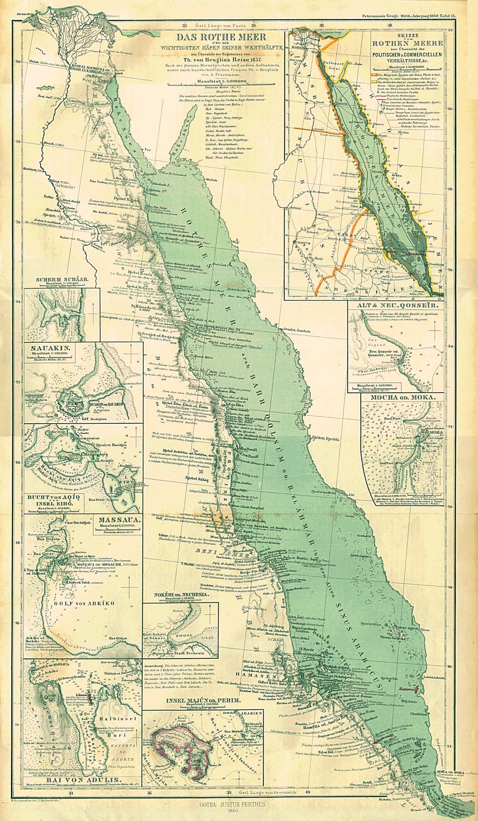
In the following centuries the canal silted up. However, part of the canal between Bubastis / Zagazig and Kassassin ( el-Qassasin ) (located about halfway to Ismailia: 30 ° 34 ' N , 31 ° 56' E ) is said to have been open in 1861. A German map from 1860 ( The Rothe Meer and the most important ports in its western half ... by A. Petermann ) shows a canal that passes the "Ruins of Heroonpolis" ("Pitom" or " Tell el-Maschouta ") to the bitter lakes and further into the Gulf of Suez.
In the course of the construction of the Suez Canal in the 19th century, this canal was restored and put into operation as a freshwater canal to supply the construction workers and to enable agriculture in the neighboring towns. This freshwater canal, which runs from Cairo via Ismailia to Suez, still exists.
Cartographic representation

The map from 1857 (stamped May 1, 1862) shows not only the Suez Canal and the Freshwater Canal (horizontally in the center of the picture) that are under construction, but also a series of information on ancient places and canals.
The legend goes:
- Freshwater canal and part of the maritime channel that is open to barge traffic;
- Part of the maritime channel in progress;
- Parts of the maritime channel whose construction has not yet started;
- Parts of the route below sea level;
- Ouady property owned by the Compagnie du Canal maritime de Suez.
In the version with a higher resolution and with the magnifying glass function (click) the following entries can be seen, starting at the bottom left of Cairo:
- Vieux Caire / Anc (ien) Babylon (Old Cairo / Babylon as the old name of Cairo)
- Masr / Le Caire (Arabic and French name for Cairo)
- ancien Canal de Trajan, d'Adrien et d'Amrou (old Canal of Trajan, Hadrian and Amr ibn al-As)
- Canal de Jonction d'irrigation et de navigation alimenté par les eaux du Nil (irrigation and shipping connecting canal, fed by the water of the Nile)
- Bilbeis
- Zagazig / Tel Basta / ancien Bubastis (Zagazig / whose Arabic name Tel Basta / old Bubastis)
- Ancienne Branche Pélusiaque (old Pelusich arm of the Nile)
- Canal de l'Ouadee / Canal des Ptolémé (Canal des Wadi, Canal of the Ptolemies)
- Abasee / ancienne Awaris (place Abasee, old Avaris)
- Tel el ouadee / ancient Toum et Pithoum (place Tel el ouadee, old Toum and Pithom)
- Domaine de l'Ouady (property of Ouady)
- Canal d'Eaux douce (freshwater canal)
- Tel el masrouta; heroan heropolis; Ramses (Tel el-Maskhutah, ... Heroopolis ...)
- Lac Timsah (Timsahsee)
north:
- Seuil d'El Guirs (threshold of El Guirs)
- Kantara
- Tel Deffeneh, ancient Daphne (old Daphne)
- ( top right ) Golfe de Peluse (Bay of Pelusium)
- ( at the southernmost point of the bay ) Tel el amarchine / ancienne Peluse (old Pelusium)
southern:
- Sérapéum, monument persepolitain (Serapeum, Persian Monument)
- Canal d'eau douce (freshwater canal)
- Bassin de l'Isthme. Anciennement occupé par la mer Rouge appelé aujourd'hui Lacs amèrs (Isthmus basin. Formerly part of the Red Sea, now called bitter lakes)
- Grand Canal Maritime (Great Shipping Canal)
- Forteresse d'Agerout (Fortress of Agerout, otherwise also called Ageroud)
- Suez
- Rade de Suez (Roads of Suez)
literature
- Oskar Brendl: The importance of the Suez Canal in the past and present. In: Journal of Economic Geography. Buchenverlag, Bad Soden 1975, ISSN 0044-3751 , Vol. 9, pp. 212-219.
- Josef Feix: Herodotus - Histories. Artemis & Winkler, Düsseldorf 2004, ISBN 3-7608-4111-2 .
- Ernesto Kienitz: The Suez Canal - Its history, economic importance and political problems. Reimer, Berlin 1957.
Web links
- Suez Canal . In: Encyclopædia Britannica . 11th edition. tape 26 : Submarine Mines - Tom-Tom . London 1911, p. 25 (English, full text [ Wikisource ]).
- Tassie Hassan & van Wetering: About the excavation near the village of Kafr Hassan. On: KAFR HASSAN DAWOOD On-Line , 2003, accessed June 13, 2009
- The Columbia Encyclopedia, Sixth Ed. 2001-07, Suez Canal , accessed May 3, 2009
- Arnold T. Wilson, The Suez Canal , Digitization
- R. Stahl and AB Ramadan: Environmental Studies on Water Quality of the Ismailia Canal / Egypt. Research Center Karlsruhe, August 2008 (PDF file; 2.20 MB)
Individual evidence
- ↑ a b c d e f g h i j k l m Hadwiga Schörner: Artificial shipping canals in antiquity . In: Skyllis - Journal for Underwater Archeology (Skyllis) Volume 3, Issue 1, 2000, pp. 38–43.
- ↑ a b c d Suez Canal . In: Encyclopædia Britannica . 11th edition. tape 26 : Submarine Mines - Tom-Tom . London 1911, p. 25 (English, full text [ Wikisource ]).
- ^ Canal History. Suez Canal Authority, accessed March 19, 2017 .
- ↑ History of seafaring
- ^ Herodotus, Historien II 158.
- ↑ Herodotus, Historien IV 39
- ^ Herodotus, Historien IV 42
- ↑ quoted from Hadwiga Schörner: Artificial shipping canals in antiquity . In: Skyllis - Journal for Underwater Archeology (Skyllis) Volume 3, Issue 1, 2000, pp. 38–43.
- ^ Darius' Suez Inscriptions. Livius.org
- ↑ a b Description de l'Égypte, Cartes, Feuille 23 , accessed on November 23, 2011
- ↑ Description de l'Égypte, État Moderne Vol. I, Planche 11 - Isthme de Soueys - , accessed on 23 November 2011
- ↑ a b c d Hassan, Tassie & van Wetering on the excavation near the village of Kafr Hassan Dawood, 2003 , on ECHO - Egyptian Cultural Heritage Organization; Accessed June 13, 2009
- ↑ Poznan, quoted in Hadwiga Schörner: Artificial shipping channels in antiquity . In: Skyllis - Journal for Underwater Archeology (Skyllis) Volume 3, Issue 1, 2000, pp. 38–43.
- ^ Arnold T. Wilson: The Suez Canal. Oxford University Press, London 1933.
- ^ Egypt, New Kingdom , from Putzger's: Historischer Schul-Atlas. 39th edition, 1917.
- ↑ Description de l'Égypte, Cartes, Feuille 30 and Feuille 31 , accessed on November 23, 2011
- ↑ Herodotus (H 7.24) mentions the same width for the Xerxes Canal in Chalkidiki , which can give rise to doubts.
- ^ About Suez Canal. Suez Canal Authority, accessed March 19, 2017 .
- ↑ Even today it would only be possible with an unjustifiable effort for the seal, but it would probably not work absolutely reliably
- ↑ The Rothe Meer and the most important ports in its western half ... by A. Petermann ; Perry-Castañeda Library, The University of Texas