Budemichgraben
| Budemichgraben | ||
|
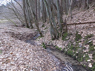
The Budemichgraben in the Näßlichgrund nature reserve |
||
| Data | ||
| location |
Spessart
|
|
| River system | Rhine | |
| Drain over | Näßlichbach → Kinzig → Main → Rhine → North Sea | |
| source | on the outskirts of Geiselbach 50 ° 7 ′ 40 ″ N , 9 ° 11 ′ 25 ″ E |
|
| Source height | 285 m above sea level NHN | |
| muzzle | east of Horbach in den Näßlichbach Coordinates: 50 ° 8 '15 " N , 9 ° 10' 56" E 50 ° 8 '15 " N , 9 ° 10' 56" E |
|
| Mouth height | 210 m above sea level NHN | |
| Height difference | 75 m | |
| Bottom slope | 50 ‰ | |
| length | 1.5 km | |
| Catchment area | 65 ha | |
|
The Budemichgraben (front left) flows into the Näßlichbach (from right to back) |
||
The Budemichgraben is a left tributary of the Näßlichbach in the Bavarian and Hessian Spessart .
geography
course

The Budemichgraben rises in the forest on the northern outskirts of Geiselbach , on the border between the Bavarian Geiselbacher Forest (unincorporated until 2015) in the Aschaffenburg district and the Hessian Freigericht in the Main-Kinzig district . It flows parallel to the left extending Highway 3269 as a border Bach north and reaches the Wiesengrund the protected landscape Näßlichgrund . There it flows the last 100 m in Hesse and flows east of Horbach , near the Mariengrotte, from the left into the Näßlichbach .
In the past, the Budemichgraben was also seen as the border stream to the historic Hohen Mark . Even today it limits the range of the Sölzert . The peaks of the Heidköpfe (337 m) extend on its left .
Kinzig river system
See also
Web links
Individual evidence
- ↑ a b c d BayernAtlas of the Bavarian State Government ( notes )
- ↑ Hessenviewer (Geoportal Hessen) of the Hessian State Office for Soil Management and Geoinformation with property mapping ( information )

