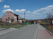
Bugaj (Kalwaria Zebrzydowska)
| Bugaj | ||
|---|---|---|
 Help on coat of arms |
|
|
| Basic data | ||
| State : | Poland | |
| Voivodeship : | Lesser Poland | |
| Powiat : | Wadowice | |
| Gmina : | Kalwaria Zebrzydowska | |
| Geographic location : | 49 ° 51 ′ N , 19 ° 40 ′ E | |
| Height : | 310-515 m npm | |
| Residents : | ||
| Postal code : | 34-130 | |
| Telephone code : | (+48) 33 | |
| License plate : | KWA | |
Bugaj is a village with a Schulzenamt of the municipality Kalwaria Zebrzydowska in the Powiat Wadowicki of the Lesser Poland Voivodeship , Poland .
geography
The neighboring towns are the town of Kalwaria Zebrzydowska in the north, Brody in the east, Stronie and Leśnica in the south.
history
Until around 1584, the area of today's village was still forested and unpopulated. It was then illegally colonized by Mikołaj Zebrzydowski. The unclear situation was first accepted in 1593.
During the first partition of Poland in 1772, Bugaj came to the new Kingdom of Galicia and Lodomeria of the Habsburg Empire (from 1804).
In 1918, after the end of the First World War and the collapse of the Austro-Hungarian monarchy, Bugaj came to Poland. This was only interrupted by the occupation of Poland by the Wehrmacht in World War II . It then belonged to the General Government .
From 1975 to 1998 Bugaj was part of the Bielsko-Biała Voivodeship .
Individual evidence
- ↑ Julian Zinkow: Wokół Kalwarii Zebrzydowskiej i lanckorona . Wydawnictwo "CALVARIANUM", Kalwaria Zebrzydowska 2000, ISBN 83-8739541-2 , p. 258-263 (Polish).
- ↑ Dz.U. 1975 no 17 poz. 92 (Polish, PDF; 783 kB)


