
Caazapá Department
| Caazapá Department | ||
|---|---|---|
  |
||
| Symbols | ||
|
||
| Basic data | ||
| Country | Paraguay | |
| Capital | Caazapá | |
| surface | 9496 km² | |
| Residents | 187,000 ( 2018 estimate ) | |
| density | 20 inhabitants per km² | |
| ISO 3166-2 | PY-6 | |
 |
||

Coordinates: 26 ° 12 ′ S , 56 ° 22 ′ W
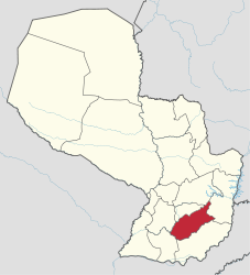
Caazapá ( Guaraní : Ka'asapa ) is a department in Paraguay with about 187,000 inhabitants. It is one of a total of 17 administrative districts . It borders in the north on Caaguazú and Guairá , in the south on Itapúa , in the east on Alto Paraná and in the west on the Departamento Misiones and Paraguarí .
history
Caazapá is one of the areas with the earliest consolidated population in Paraguay. The Franciscans (OFM) contributed to this through the founding of the missions in Caazapá in 1607 and Yutí in 1610. At the beginning of the 20th century, the construction of the railway line to the port of Encarnación led to other local foundations along the route, such as Yhacanguazú, Iturbe, Maciel , Estación Sosa (now Moisés Bertoni) and Yegros. In 1906 the Caazapá department was created.
economy
It is mainly used for agriculture and animal husbandry. The main products are: wheat, soy, rice, corn, sugar cane and tobacco. In animal husbandry, cattle come first, followed by the sharp rise in the number of pigs. Caazapá is the poorest department of Paraguay, 47.9% of the population live below the poverty line (as of 2016).
Districts
- Abaí
- Buena Vista
- Caazapá
- Doctor Moisés S. Bertoni
- Fulgencio Yegros
- General Higinio Morinigo
- Maciel
- San Juan Nepomuceno
- Tavaí
- Yuty
Individual evidence
- ↑ Caazapá dgeec.com (PDF) , accessed November 6, 2018.
- ↑ Caazapá, San Pedro y Caaguazú son los departamentos más pobres del país ultimahora.com , May 10, 2016, accessed on November 6, 2018.
Alto Paraguay | Alto Paraná | Amambay | Boquerón | Caaguazú | Caazapá | Canindeyú | Central | Concepción | Cordillera | Guairá | Itapúa | Misiones | Ñeembucú | Paraguarí | Presidente Hayes | San Pedro | Capital District: Asunción