Department of Concepción (Paraguay)
| Concepción | |||
|---|---|---|---|
| Symbols | |||
|
|||
| Basic data | |||
| Country | Paraguay | ||
| Capital | Concepción | ||
| surface | 18,051 km² | ||
| Residents | 244,100 ( 2017 estimate ) | ||
| density | 14 inhabitants per km² | ||
| ISO 3166-2 | PY-1 | ||
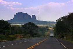
| The Cerro Memby on Ruta 5 in Dep. Concepción | |||
Coordinates: 23 ° 24 ′ S , 57 ° 26 ′ W
Concepción is a department in Paraguay , it is one of a total of 17 administrative districts . The Department of Concepción is divided into 7 districts: Concepción, Horqueta, Yby Yaú, San Lázaro, Loreto, Belén and San Carlos, the smallest district in terms of population in the country with the largest national park in Eastern Paraguay.
history
Concepción was formed as a region after Fernando de Pinedo founded the Fort Villa Real de Concepción in 1773 . The main purpose of this foundation was to protect the flourishing colonies in a south-westerly direction, such as Asunción , from Brazilian privateers ( Bandeirantes ) and warlike Indian tribes such as the Guaicurú and the Mbayá .
The first cattle breeding of the Spanish royal family in the New World was located in Concepción. At the end of the 19th century, Concepción experienced a wave of immigration, which brought mainly settlers from Lebanon , Syria , Italy and Spain ( Catalonia ). This brought about the establishment of Concepción as a trading center. After the Chaco War , trade shifted more and more to other regions, but the cement and lime industry and the yerba mate industry remained stable.
Economy and Transport
Concepción is located on the main waterway of the country, the Río Paraguay , which is navigable in its full length in this department. The distance to the capital Asunción is 310 km (waterway) and via the Via Ruta 5 Gral. Bernardino Caballero and via the 3 Grail Route, Elizardo Aquino , the distance is 543 km. Other important waterways are the Río Apa , Río Aquidabán and Río Ypané , which are the only permanently usable routes in some regions. Around 250 km of the roads are paved, and there are around 500 km of unpaved roads. As an alternative, there are various flight connections, both from private companies and scheduled flights operated by the military .
The Puente Nanawa bridge connects the city of Concepción with the Department of Presidente Hayes . In addition to the Puente Remanso near Asunción , this is one of only two bridges over the Río Paraguay in the entire national territory.
In the north of Concepción is the Cordillera San Luis . This is known for its calcareous rocks, so that the entire state production of clinker and Portland cement has settled in this region. The center of the cement trade is the city of Vallemí .
Besides the timber industry, the main source of income is cattle breeding . Yerba mate is still planted and processed in isolated cases, but this branch of industry is in decline. The highly calcareous soil is also used to grow sugar cane and cotton. Because of the monoculture and the excessive timber yield, alternatives in agriculture are now being sought, such as the cultivation of sesame , watermelon , coffee and coconut.
Nature reserves
To this day, Concepción has 5 official nature reserves in the so-called Ecoregión del Aquidabán.
- Paso Bravo 93,600 hectares
- Serranía San Luis , 10,282 ha
- Itapucumí , 45,000 ha
- Estrella de Concepción , 2,400 ha
- Laguna Negra , 10 ha.
The puma , jaguars , toucans , anacondas , Chaco peccaries , broad -snouted caimans , South American otters , hyacinth macaws and green-winged macaws are particularly worthy of protection because they are threatened with extinction .
Districts
Web links and sources
- http://www.abc.com.py/paraguay/Iconcepcion.htm
- http://www.salvemoslos.com.py/
- Geografía Ilustrada del Paraguay, Distribuidora Arami SRL; 2007. ISBN 99925-68-04-6
Individual evidence
- ↑ Paso Bravo - National Park or Cattle Ranch? nationalparksofparaguay.blogspot.com , April 2, 2014, accessed December 9, 2018.


