
Campo Largo (Paraná)
| Município de Campo Largo "Capital da Louça"
Campo Largo
|
|||
|---|---|---|---|
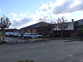
 Panoramic view, the Schmidt porcelain factory in the foreground
|
|||
|
|||
| Coordinates | 25 ° 28 ′ S , 49 ° 32 ′ W | ||
 Location of the municipality in the state of Paraná Location of the municipality in the state of Paraná
|
|||
| Symbols | |||
|
|||
| founding | 2nd April 1870 (age 150) | ||
| Basic data | |||
| Country | Brazil | ||
| State | Paraná | ||
| ISO 3166-2 | BR-PR | ||
| Metropolitan area | Curitiba | ||
| height | 956 m | ||
| climate | tropical, cfb | ||
| surface | 1,243.6 km² | ||
| Residents | 112,377 (2010) | ||
| density | 90.4 Ew. / km² | ||
| estimate | 132.002 (July 1, 2019) | ||
| Parish code | IBGE : 4104204 | ||
| Post Code | 83601-000 | ||
| Telephone code | (+55) 41 | ||
| Time zone | UTC −3 | ||
| Website | campolargo.pr (Brazilian Portuguese) | ||
| politics | |||
| City Prefect | Marcelo Fabiani Puppi (2017-2020) | ||
| Political party | Democratas | ||
| economy | |||
| GDP | 3,811,584 thousand R $ 30,318 R $ per person (2016) |
||
| HDI | 0.745 (high) (2010) | ||


Campo Largo , officially Portuguese Município de Campo Largo , is a city in the Brazilian state Paraná of the Região Sul . In the 2010 census year it had 112,377 inhabitants, the population of the Campo-Larguensians was estimated on July 1, 2019 at 132,002 inhabitants, who live in a community area of around 1243.6 km². The calculated population density is 90 people per km², in fact over 83% are concentrated in the urban area. Based on the population, it is in 19th position of the 399 municipalities in the state, and in 29th position in terms of area. It is part of the metropolitan region of Curitiba , also known as Grande Curitiba, with another 28 municipalities . The distance to the capital Curitiba is 30 km.
It bears the city nickname "Capital da Louça" (capital of dishes). The mining of kaolin and clay for industrial ceramics and porcelain production make up a significant part of the community's economic activity.
geography
Surrounding communities are Castro , Campo Magro , Itaperuçu , Ponta Grossa , Araucária , Balsa Nova , Curitiba and Palmeira .
The biome is Mata Atlântica . The center is at an altitude of 956 meters above sea level.
climate
The city has a tropical temperate mountain climate, Cfb according to the Köppen and Geiger climate classification . The average temperature is 16.7 ° C. The average rainfall is 1481 mm per year.
Local government
The executive rests with the city prefect (mayor). In the 2016 local elections , Marcelo Fabiani Puppi was elected city prefect by the Democratas for the 2017-2020 term.
The legislature lies with an elected 12-member city council, the vereadores of the Câmara Municipal.
Population development
| year | Residents | city | country |
|---|---|---|---|
| 1872 |
6,856: 6338 free, 518 slaves |
||
| 1900 | 10,968 | ||
| 1920 | 19,149 | ||
| 1940 | 22,549 | 2,956 | 19,593 |
| 1950 | 26,365 | 4.032 | 22,333 |
| 1960 | 32,272 | 9,150 | 23,122 |
| 1970 | 34,405 | 15,961 | 18,444 |
| 1980 | 54,834 | 37,366 | 17,468 |
| 1991 | 72,523 | 51,892 | 18,631 |
| 2000 | 92,782 | 77.223 | 15,559 |
| 2010 | 112,486 | 94,353 | 18,233 |
| 2019 | 132.002 | ? | ? |
 |
|||
Source: IBGE (2011)
Ethnic composition
Ethnic groups according to the statistical classification of the IBGE (as of 2000 with 92,782, as of 2010 with 112,486 inhabitants):
| group | Share 2000 |
Share 2010 |
annotation |
|---|---|---|---|
| Brancos | 76,608 | 88,923 | Whites, descendants of Europeans |
| Pardos | 12,863 | 20.002 | Mixed races, mulattos , mestizos |
| Pretus | 2,476 | 2,961 | black |
| Amarelos | 47 | 387 | Asians |
| Indigenous people | 162 | 104 | indigenous population |
| without specification | 628 | - |
Illiteracy rate
Campo Largo had an illiteracy rate of 16% in 1991 (including incomplete primary schooling), which had already fallen to 5.6% in the 2010 census. Around 23.4% of the population in 2010 were children and adolescents up to the age of 15.
| Illiteracy rate | ||||
|---|---|---|---|---|
| year | percent | |||
| 1991 | 15.98 | |||
| 2000 | 8.70 | |||
| 2010 | 5.58 | |||
Average income and standard of living
In 2017, the average monthly income was 2.5 times the Brazilian minimum wage ( Salário mínimo ) of R $ 880.00 (income converted for 2019: around € 498 per month). The Human Development Index (HDI) is rated high at 0.745 for 2010.
In 2017, 33,268 people or 26.1% of the population were registered as permanently employed; in 2010, 30.3% of the population had an income of half the minimum wage.
| HDI | ||||
|---|---|---|---|---|
| year | Points | |||
| 1991 | 0.486 | |||
| 2000 | 0.639 | |||
| 2010 | 0.745 | |||
The gross national product per capita in 2016 was R $ 30,318.28, the gross national product of the municipality amounted to 3,811,583.54 × R $ thousand in 2016. Campo Largo was the 15th place of the 399 municipalities of the state and 233rd of the 5570 municipalities of Brazil.
Transport links
| Road links | ||||
|
|
From Curitiba via Campo Largo to Balsa Nova |
|||
|
|
From Araucária to Campo Largo |
|||
Sons and daughters
- Celso Antônio Marchiori (* 1958) Roman Catholic clergyman, Bishop of São José dos Pinhais
- Antônio Agostinho Marochi (1925–2018), Roman Catholic clergyman, Bishop of Presidente Prudente
literature
- Diário Official do Município , municipal gazette (Brazilian Portuguese)
- Caderno estatístico Munícipio de Campo Largo. (PDF) Instituto Paranaense de Desenvolvimento Econômico e Social - IPARDES, Curitiba, November 2019(Brazilian Portuguese).
Pictures from Campo Largo

historical Museum
town hall

Main church of Nossa Senhora da Piedade
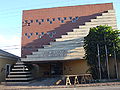
Culture house


Web links
- City Prefecture website , Prefeitura Municipal (Brazilian Portuguese)
- City Council website , Câmara Municipal (Brazilian Portuguese)
Individual evidence
- ↑ a b c Campo Largo - Panorama. In: cidades.ibge.gov.br. IBGE , accessed November 26, 2019 (Brazilian Portuguese).
- ↑ Campo Largo climate: average temperature, weather by month, Campo Largo weather averages - Climate-Data.org. In: de.climate-data.org. Retrieved November 26, 2019 .
- ↑ Marcelo Puppi 25 (Prefeito). In: todapolitica.com. Eleições 2016, accessed November 26, 2019 (Brazilian Portuguese).
- ^ A b Atlas do Desenvolvimento Humao no Brasil: Campo Largo, PR . Retrieved November 27, 2019 (Brazilian Portuguese)
- ↑ Censos demográficos do IBGE (1872-2010). Evolução da divisão territorial do Brasil 1872–2010 , p. 229. (Online; PDF; 125.3 MB)
- ↑ IBGE : Sistema IBGE de Recuperação Automática - SIDRA: Tabela 2093. Accessed on November 27, 2019 (Portuguese, database query, search terms Campo Largo (PR) and Cor ou raça).
- ↑ Campo Largo - Panorama - Trabalho e rendimento. In: cidades.ibge.gov.br. IBGE , accessed November 27, 2019 (Brazilian Portuguese).
- ↑ Campo Largo - Produto Interno Bruto dos Municipios. In: cidades.ibge.gov.br. IBGE , accessed November 27, 2019 (Brazilian Portuguese).