
Ponta Grossa
| Município de Ponta Grossa Princess dos Campos
Ponta Grossa
|
|||
|---|---|---|---|
 View of the center
|
|||
|
|||
| Coordinates | 25 ° 5 ′ S , 50 ° 10 ′ W | ||
 Location of the municipality in Paraná Location of the municipality in Paraná
|
|||
| Symbols | |||
|
|||
| founding | April 7, 1855 as Vila de Ponta Grossa | ||
| Basic data | |||
| Country | Brazil | ||
| State | Paraná | ||
| ISO 3166-2 | BR-PR | ||
| height | 975 m | ||
| Waters | Rio Pitangui , Represa dos Alagados | ||
| climate | subtropical, cfb | ||
| surface | 2,054.7 km² | ||
| Residents | 311,611 (2010) | ||
| density | 151.7 Ew. / km² | ||
| estimate | 348,043 (July 1, 2018) | ||
| Parish code | IBGE : 4119905 | ||
| Post Code | 84.015-000 | ||
| Telephone code | (+55) 42 | ||
| Time zone | UTC -3 | ||
| Website | www.pontagrossa.pr.gov.br (Brazilian Portuguese) | ||
| politics | |||
| City Prefect | Marcelo Rangel (2017-2020) | ||
| Political party | PSDB | ||
 Panoramic view of Ponta Grossa
|
|||


Ponta Grossa , officially Portuguese Município de Ponta Grossa , is a major city in Brazil in the state of Paraná . It is located about 115 km west of the capital Curitiba in a region known as Campos Gerais do Paraná . According to the 2010 census, the population was 311,611 people known as pontagrossenses . The population estimate from July 1, 2018 already names 348,043 residents. The Munizip Ponta Grossa is the fourth largest city in Paraná and has the largest industrial park within the state. She is also known as Princess dos Campos and gained city status in 1855.
Ponta Grossa is the seat of the diocese of Ponta Grossa .
geography
Hydrography

Ponta Grossa and the surrounding area is an area with many rivers, including the Rio Tibaji , Rio Verde , Rio Pitangui , Rio Botuquara , Rio São Jorge and other tributaries.
climate
The climate is subtropical and humid ( Cfb according to the Köppen and Geiger climate classification ), with mild summers and cold, with occasional frost in winter and an average temperature of 21.4 ° C in summer and 13.8 ° C in winter. Annual average in 2008 = 17.6 ° C
- Absolute minimum: 6 ° C in July 1975
- Maximum total: 36.2 ° C in January 1958
population
The population consists of different ethnic groups and is around 80% white. In its early days, Ponta Grossa was populated by bandeirantes (border residents), Portuguese and famous families from São Paulo . At the beginning of the 20th century, Slavs (Russians, Poles and Ukrainians), Arabs , Italians , Japanese , Dutch and Germans settled. The Germans and Slavs were the most numerous and, consequently, it is these who have made the greatest impact in the customs and culture.
City structure
Since 1962, Ponta Grossa has been divided into the five administrative districts of Ponta Grossa, Guaragi , Itaiacoca , Periquitos and Uvaia and comprises 15 Bairros (districts): Boa Vista, Cará Cará, Centro, Chapada, Colônia Dona Luiza, Contorno, Vila Estrela, Jardim Carvalho, Neves, Nova Rússia, Bairro de Oficinas, Olarias, Órfãs, Ronda and Uvaranas.
City administration
The city is administered by the city prefecture ( prefeitura municipal ) as the executive and the city chamber ( Câmara Municipal ) as the legislature.
The incumbent city prefect for the 2017 to 2020 term of office is Marcelo Rangel , who is now a member of the Partido da Social Democracia Brasileira (PSDB).
Attractions

Rocks in Vila Velha
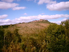
Vila Velha Natural Park
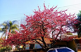
Prunus Serrulata in a subtropical climate

Former station building


Town twinning
sons and daughters of the town
- Francisco Carlos Bach (* 1954), Roman Catholic clergyman, Bishop of Joinville
- Denisse de Kalafe (* 1949), Mexican singer-songwriter
Web links
- City Prefecture website (Brazilian Portuguese)
- Câmara Municipal website (Brazilian Portuguese)
Individual evidence
- ↑ a b IBGE : Ponta Grossa - Panorama. In: gov.br. Retrieved May 8, 2019 (Brazilian Portuguese).
- ↑ a b IBGE : Estimativas da população residente no Brasil e unidades da federação com data de referência em 1 ° de julho de 2018. (PDF; 2.6 MB) In: ibge.gov.br. 2018, accessed May 8, 2019 (Brazilian Portuguese).
- ↑ Marcelo Rangel Cruz Oliveira 23 (Prefeito). In: www.eleicoes2016.com.br. Eleições 2016, accessed May 8, 2019 (Brazilian Portuguese).