Campo Mourão
| Município de Campo Mourão Campo Mourão |
|||
|---|---|---|---|
|
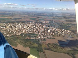
Aerial photograph (2010)
|
|||
|
|
|||
| Coordinates | 24 ° 3 ′ S , 52 ° 23 ′ W | ||
 Location of the municipality in the state of Paraná Location of the municipality in the state of Paraná
|
|||
| Symbols | |||
|
|||
| founding | 10th October 1947 (age 72) | ||
| Basic data | |||
| Country | Brazil | ||
| State | Paraná | ||
| ISO 3166-2 | BR-PR | ||
| structure | 2 districts | ||
| height | 630 m | ||
| Waters | Rio Mourão | ||
| climate | tropical, Cfa | ||
| surface | 749.6 km² | ||
| Residents | 87,194 (2010) | ||
| density | 116.3 Ew. / km² | ||
| estimate | 94,859 (July 1, 2019) | ||
| Parish code | IBGE : 4104303 | ||
| Post Code | 87301-100 | ||
| Telephone code | (+55) 44 | ||
| Time zone | UTC −3 | ||
| Website | campomourao (Brazilian Portuguese) | ||
| politics | |||
| City Prefect | Tauillo Tezelli (2017-2020) | ||
| Political party | PPS | ||
| economy | |||
| GDP | 3,367,842 thousand. R $ 36,002 R $ per capita (2016) |
||
| HDI | 0.757 (high) (2010) | ||
Campo Mourão (officially Município de Campo Mourão ) is a city in the Brazilian state of Paraná . It had 87,194 inhabitants in the 2010 census year, these Campo-Mourensians were estimated to be 94,859 inhabitants as of July 1, 2019, who live on a community area of around 749.6 km². Around 95% of the population is concentrated in the urban core, arithmetically the population density is 116 people per km², it is in 21st place of the most populous municipalities in the state.
It is located at an altitude of 630 meters above sea level. The distance to the capital Curitiba is around 460 km.
geography
Surrounding communities are Peabiru , Barbosa Ferraz , Luiziana , Corumbataí do Sul , Farol , Mamborê and Araruna .
The predominant biome is Mata Atlântica , the soil is fertile thanks to Terra Roxa . It lies on the basaltic Terceiro Planalto Paranaense ( Third Paranaian Plateau ), also known as Planalto de Guarapuava . It has a share in the state park Parque Estadual Lago Azul .
Hydrography
The community is located in the basin of the Rio Ivaí and belongs to the watershed of the Rio Paraná . Its main river is the Rio Mourão , which flows through the municipality in a north-south direction. It has a share in the Represa Mourão reservoir with a hydroelectric power plant of 8 MW.
climate
The city has a tropical temperate climate, Cfa according to the Köppen and Geiger climate classification . The average temperature is 19.9 ° C. The average rainfall is 1570 mm per year.
history
Temporal sequence of affiliations until independence, the discovery follows from the coast into the hinterland, where the great expanses of tropeiros had been explored: Paranaguá , created by royal charter of July 29, 1648, from which Curitiba emerged on March 29, 1693, from Curitiba, Castro (Paraná) was spun off on September 24, 1788, from Castro on July 17, 1852 Guarapuava , from Guarapuava on December 30, 1943, Pitanga (Paraná) and from Pitanga on October 10, 1947 Campo Mourão, the actual emancipation took place on December 5, 1947, which is the founding date in the city arms.
Local government
The executive rests with the city prefect (mayor). In the local elections in 2016 , Tauillo Tezelli was elected city prefect by the Partido Popular Socialista (PPS) for the term from 2017 to 2020. Tezelli had been mayor from 1997 to 2005.
The legislature lies with an elected 13-member city council, the vereadores of the Câmara Municipal.
The municipality is divided into two districts, the Distrito de Campo Mourão (municipal seat ) and the Distrito de Piquirivaí , the city divided into numerous named bairros .
List of city prefects
| No. | Surname | from ... to |
| 1 | José Antônio dos Santos | in 1947 |
| 2 | Pedro Viriato de Souza Filho | 1947-1950 |
| 3 | Devete de Paula Xavier | 1950 |
| 4th | Joaquim Teodoro de Oliveira | 1951 |
| 5 | Daniel Portela | 1951-1955 |
| 6th | Roberto Brzezinski | 1955-1959 |
| 7th | Paulo Vinicius Fortes | 1959 |
| 8th | Antonio Teodoro de Oliveira | 1959-1963 |
| 9 | Milton Luiz Pereira | 1963-1967 |
| 10 | Rosalino Mansuetto Salvadori | 1967-1968 |
| 11 | Augustinho Vecchi | 1968-1969 |
| 12 | Horacio Amaral | 1969-1973 |
| 13 | Renato Fernandes Silva | 1973-1977 |
| 14th | Augustinho Vecchi | 1977-1983 |
| 15th | José Pochapski | 1983-1989 |
| 16 | Augustinho Vecchi | 1989-1993 |
| 17th | Rubens Bueno | 1993-1997 |
| 18th | Tauillo Tezelli | 1997-2005 |
| 19th | Nelson Jose Tureck | 2005 - 2012 |
| 20th | Regina Dubay | 2013-2016 |
| 21st | Tauillo Tezelli | 2017-2020 |
Population development
Since 1950, nine more independent cities have emerged from the area of Campo Mourão.
| year | Residents | city | country |
|---|---|---|---|
| 1950 | 32,948 | 836 | 32,112 |
| 1960 * | 141.157 | 19,489 | 121,668 |
| 1970 | 77.118 | 27,911 | 49.207 |
| 1980 | 75,423 | 49,339 | 26,084 |
| 1991 | 82,318 | 72,335 | 9,983 |
| 2000 | 80,476 | 74,754 | 5,722 |
| 2010 | 87,287 | 82,757 | 4,530 |
| 2019 | 94,859 | ? | ? |
 |
|||
Source: IBGE (2011) - Note *: Territorial reforms
Ethnic composition
Ethnic groups according to the statistical classification of the IBGE (as of 2000 with 80,476, as of 2010 with 87,287 inhabitants):
| group | Share 2000 |
Share 2010 |
annotation |
|---|---|---|---|
| Brancos | 60,736 | 57,513 | Whites, descendants of Europeans |
| Pardos | 16,685 | 25,317 | Mixed races, mulattos , mestizos |
| Pretus | 1,945 | 3,000 | black |
| Amarelos | 761 | 1,175 | Asians |
| Indigenous people | 222 | 189 | indigenous population |
| without specification | 128 | - |
Illiteracy rate
Campo Mourão had an illiteracy rate of 21% in 1991 (including incomplete primary education), which had already fallen to 9.2% in the 2010 census. Around 22% of the population in 2010 were children and adolescents up to the age of 15.
| Illiteracy rate | ||||
|---|---|---|---|---|
| year | percent | |||
| 1991 | 21.01 | |||
| 2000 | 13.90 | |||
| 2010 | 9.23 | |||
Average income and standard of living
In 2017, the average monthly income was 2.5 times the Brazilian minimum wage ( Salário mínimo ) of R $ 880.00 (income converted for 2019: around € 498 per month). The Human Development Index (HDI) is rated high at 0.757 for 2010.
In 2017, 29,777 people or 31.6% of the population were registered as permanently employed; 29.9% of the population had an income of half the minimum wage in 2010.
| HDI | ||||
|---|---|---|---|---|
| year | Points | |||
| 1991 | 0.524 | |||
| 2000 | 0.675 | |||
| 2010 | 0.757 | |||
The gross national product per capita was R $ 36,001.60 in 2016, the gross national product of the municipality was R $ 3,367,841.53 × thousand in 2016. Campo Mourão was the 18th place of the 399 municipalities of the state and 260th of the 5570 municipalities of Brazil.
Transport links
| Road links | ||||
|
|
Campo Mourão - Naviraí (MS) - Cruzeiro do Oeste (Boiadeira) - Guarapuava - Curitiba |
|||
|
|
Campo Mourão - Peabiru - Roncadur |
|||
|
|
Campo Mourão - Araruna |
|||
|
|
Campo Mourão - Cascavel |
|||
|
|
Campo Mourão - Goioerê |
|||
The city has the airport Campo Mourão ( Aeroporto de Campo Mourão - Coronel Geraldo Guia de Aquino ), IATA: CBW , ICAO: SSKM , which has been part of a new regional flight network program of the Paraná state government since 2019.
literature
- Caderno estatístico Munícipio de Campo Mourão. (PDF) Instituto Paranaense de Desenvolvimento Econômico e Social - IPARDES, Curitiba, December 2019(Brazilian Portuguese, statistics published in progress).
Web links
- Campo Mourão Prefecture Website (Brazilian Portuguese)
- Website of the City Council , Câmara Municipal (Brazilian Portuguese)
- Histórico, Campo Mourão , short version of the city's history on the IBGE website. Retrieved July 27, 2013 (Brazilian Portuguese)
Individual evidence
- ↑ a b c Campo Mourão - Panorama. In: cidades.ibge.gov.br. IBGE , accessed December 1, 2019 (Brazilian Portuguese).
- ^ Paraná - Cola da Web. In: coladaweb.com. Retrieved December 1, 2019 (Brazilian Portuguese, education website).
- ↑ Secretaria de Estado do Meio Ambiente e Recursos Hídricos - SEMA (ed.): Bacias hidrográficas do Paraná . Curitiba 2010 (Brazilian Portuguese, gov.br [PDF]).
- ↑ Campo Mourão climate: average temperature, weather by month, Campo Mourão weather averages - Climate-Data.org. In: de.climate-data.org. Accessed December 1, 2019 .
- ↑ Tauillo Tezelli 23 (Prefeito). In: todapolitica.com. Eleições 2016, accessed December 1, 2019 (Brazilian Portuguese).
- ↑ a b Atlas do Desenvolvimento Humao no Brasil: Campo Mourão, PR . Retrieved December 1, 2019 (Brazilian Portuguese)
- ↑ Censos demográficos do IBGE (1872-2010). Evolução da divisão territorial do Brasil 1872–2010 , p. 229. (Online; PDF; 125.3 MB)
- ↑ IBGE : Sistema IBGE de Recuperação Automática - SIDRA: Tabela 2093. Retrieved on December 1, 2019 (Portuguese, database query, search terms Campo Mourão (PR) and Cor ou raça).
- ↑ Campo Mourão - Panorama - Trabalho e rendimento. In: cidades.ibge.gov.br. IBGE , accessed December 1, 2019 (Brazilian Portuguese).
- ↑ Campo Mourão - Produto Interno Bruto dos Municípios. In: cidades.ibge.gov.br. IBGE , accessed December 1, 2019 (Brazilian Portuguese).
- ↑ Paraná ganha 11 novas rotas de voos espalhadas pelo Estado. In: www.aen.pr.gov.br. Agência Estadual de Notícias, August 6, 2019, accessed December 1, 2019 (Brazilian Portuguese).


