Carabamba District
| Carabamba District | ||
|---|---|---|
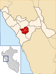
 The Carabamba district is located in the west of the Julcán province (marked in red) |
||
| Symbols | ||
|
||
| Basic data | ||
| Country | Peru | |
| region | La Libertad | |
| province | Julcán | |
| Seat | Carabamba | |
| surface | 234 km² | |
| Residents | 6828 (2017) | |
| density | 29 inhabitants per km² | |
| founding | June 19, 1990 | |
| ISO 3166-2 | PE-LAL | |
| politics | ||
| Alcalde District | Jaime Yubi Carranza Lucas (2019-2022) |
|
| Political party | Movimiento Regional Nueva Libertad | |
Coordinates: 8 ° 7 ′ S , 78 ° 36 ′ W
The Carabamba district is located in the Julcán Province in the La Libertad region in western Peru . The district was established on June 19, 1990. It has an area of 234 km². The 2017 census counted 6,828 inhabitants. In 1993 the population was 8191, in 2007 it was 7104. The district administration is located in the 3325 m high village of Carabamba with 1196 inhabitants (as of 2017). Carabamba is located 15 km southwest of the provincial capital Julcán .
Geographical location
The Carabamba district is in the west in the Julcán province. The district is bounded in the east and south by the rivers Río Palconque and Río Virú (in the upper reaches Río Huacapongo) and drained to the southwest.
The Carabamba district borders in the southwest with the district Virú ( province Virú ), in the west with the district Laredo ( province Trujillo ), in the north with the districts Salpo and Mache ( province Otuzco ), in the east with the district Julcán and in the south with the Huaso District .
Web links
- Peru: Region La Libertad (provinces and districts) at www.citypopulation.de
- INEI Perú
