Laredo district
| Laredo district | |
|---|---|
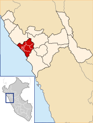
 The district of Laredo is centrally located in the province of Trujillo (marked in red) |
|
| Basic data | |
| Country | Peru |
| region | La Libertad |
| province | Trujillo |
| Seat | Laredo |
| surface | 335.4 km² |
| Residents | 37,206 (2017) |
| density | 111 inhabitants per km² |
| founding | December 28, 1961 |
| ISO 3166-2 | PE-LAL |
| politics | |
| Alcalde District | Miguel Chávez Castro (2019-2022) |
Coordinates: 8 ° 5 ′ S , 78 ° 57 ′ W
The Laredo district is located in the Trujillo Province in the La Libertad region of western Peru . Laredo District was founded on December 28, 1961. The 335.44 km² district had 37,206 inhabitants at the 2017 census. In 1993 the population was 28,019, in 2007 32,825. The administrative seat is the city of Laredo in the north of the district . Irrigated agriculture is practiced in the river valley of the Río Moche , otherwise there is desert vegetation.
Geographical location
The Laredo district is located 10 km east of the city of Trujillo . It extends over the river valley of the lower Río Moche, in the north and south the mountains of the Peruvian western cordillera rise . The Laredo district is bordered by the Moche , Trujillo and El Porvenir districts to the west, the Huanchaco district to the northeast, the Simbal district to the northeast , the Poroto district to the east, the Otuzco , Julcán and Virú provinces to the southeast and the south to the district of Salaverry .
Web links
- Peru: Region La Libertad (provinces and districts) at www.citypopulation.de
- INEI Perú
