Simbal District
| Simbal District | |
|---|---|
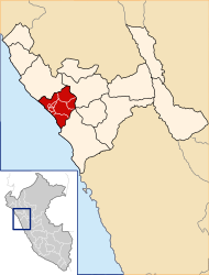
 The Simbal District is located in the northeast of the Trujillo Province (marked in red) |
|
| Basic data | |
| Country | Peru |
| region | La Libertad |
| province | Trujillo |
| Seat | Simbal |
| surface | 390.6 km² |
| Residents | 4061 (2017) |
| density | 10 inhabitants per km² |
| founding | June 24, 1824 |
| ISO 3166-2 | PE-LAL |
| politics | |
| Alcalde District | William Gonzales Narciso (2019-2022) |
| Iglesia San Juan Bautista | |
Coordinates: 7 ° 59 ′ S , 78 ° 49 ′ W
The Simbal District is located in the Trujillo Province in the La Libertad region in western Peru . The 390.55 km² district was founded on June 24, 1824. At the 2017 census, 4061 people lived in the district. In 1993 the population was 3600, in 2007 it was 4082. The administrative seat is the town of Simbal, 28 km northeast of Trujillo at an altitude of 576 m , with 874 inhabitants (as of 2017).
Geographical location
The Simbal District is located in the northeast of the Trujillo Province. It is located on the western flank of the Peruvian Western Cordillera . The Río Moche tributaries Quebrada Cahuay, Río Ñari, Río Sinsicap and Río La Cuesta flow through the district. The Río Moche runs along the southern district boundary. The mountains in the district reach heights of over 3000 m . The Simbal district borders in the northwest with the district Chicama ( province Ascope ), in the north with the district Sinsicap , in the east with the district La Cuesta (both in the province Otuzco ), in the south with the districts Poroto and Laredo and in the west with the Huanchaco District .
Web links
- Peru: Region La Libertad (provinces and districts) at www.citypopulation.de
- INEI Perú
