Poroto district
| Poroto district | |
|---|---|
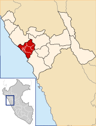
 The Poroto district is located in the east of the Trujillo Province (marked in red) |
|
| Basic data | |
| Country | Peru |
| region | La Libertad |
| province | Trujillo |
| Seat | Poroto |
| surface | 276 km² |
| Residents | 3586 (2017) |
| density | 13 inhabitants per km² |
| founding | March 7, 1964 |
| ISO 3166-2 | PE-LAL |
| politics | |
| Alcalde District | Juan Carlos Eustaquio Lucas (2019-2022) |
Coordinates: 8 ° 1 ′ S , 78 ° 46 ′ W
The Poroto District is one of 11 districts in the Trujillo Province in the La Libertad region of western Peru . Poroto District was established on March 7, 1964. The 276.01 km² district had 3586 inhabitants at the 2017 census. In 1993 the population was 4401, in 2007 3601. The administrative seat is the 627 m high village of Poroto with 796 inhabitants (as of 2017).
The Poroto district is located 30 km east-northeast of the city of Trujillo on the western flank of the Western Peruvian Cordillera . The Río Moche River flows through the district in a westerly direction. The district borders in the northwest on the Simbal district , in the extreme north on the La Cuesta district ( Otuzco province ), in the east on the Agallpampa and Salpo districts (both also in the Otuzco province) and in the south and west on the Laredo district .
Web links
- Peru: Region La Libertad (provinces and districts) at www.citypopulation.de
- INEI Perú