Salaverry District
| Salaverry District | |
|---|---|
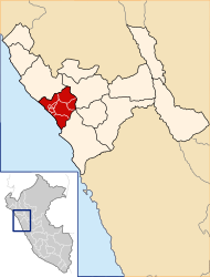
 The Salaverry district is located in the south of the Trujillo province (marked in red) |
|
| Basic data | |
| Country | Peru |
| region | La Libertad |
| province | Trujillo |
| Seat | Salaverry |
| surface | 295.9 km² |
| Residents | 18,944 (2017) |
| density | 64 inhabitants per km² |
| founding | January 4, 1879 |
| ISO 3166-2 | PE-LAL |
| Website | munisalaverry.gob.pe (Spanish) |
| politics | |
| Alcaldesa district | Mónica Betancourt (2019-2022) |
| Political party | Alianza para el Progreso |
| Aerial view of Salaverry | |
Coordinates: 8 ° 13 ′ S , 78 ° 59 ′ W
The Salaverry district is located in the Trujillo Province in the La Libertad region in western Peru . The 295.88 km² district was founded on January 4, 1879. At the 2017 census, there were 18,944 residents in the district. In 1993 the population was 8,278, in 2007 13,892. The administrative seat is the port city of Salaverry, 13 km south-southeast of Trujillo . The national road 1N ( Panamericana ) runs through the district.
Geographical location
The Salaverry district is located in the south of the Trujillo province. It stretches from the Pacific coast over the desert-like coastal plain to the mountains of the Peruvian western cordillera . This reaches heights of over 1400 m in the east of the district . The Salaverry district has an approximately 23.5 km long coastline on the Pacific Ocean and extends up to 16 km inland. The district is bordered to the northwest on the district Moche , on the north by the district Laredo and in the east and southeast of the district Virú the province of Virú .
Web links
- Municipalidad Distrital de Salaverry
- Peru: Region La Libertad (provinces and districts) at www.citypopulation.de
- INEI Perú
