
Cargados-Carajos Islands
| Cargados-Carajos Islands | |
|---|---|
 |
|
| Waters | Indian Ocean |
| archipelago | Mascarens |
| Geographical location | 16 ° 35 ' S , 59 ° 37' O |
 |
|
| Number of islands | 22nd |
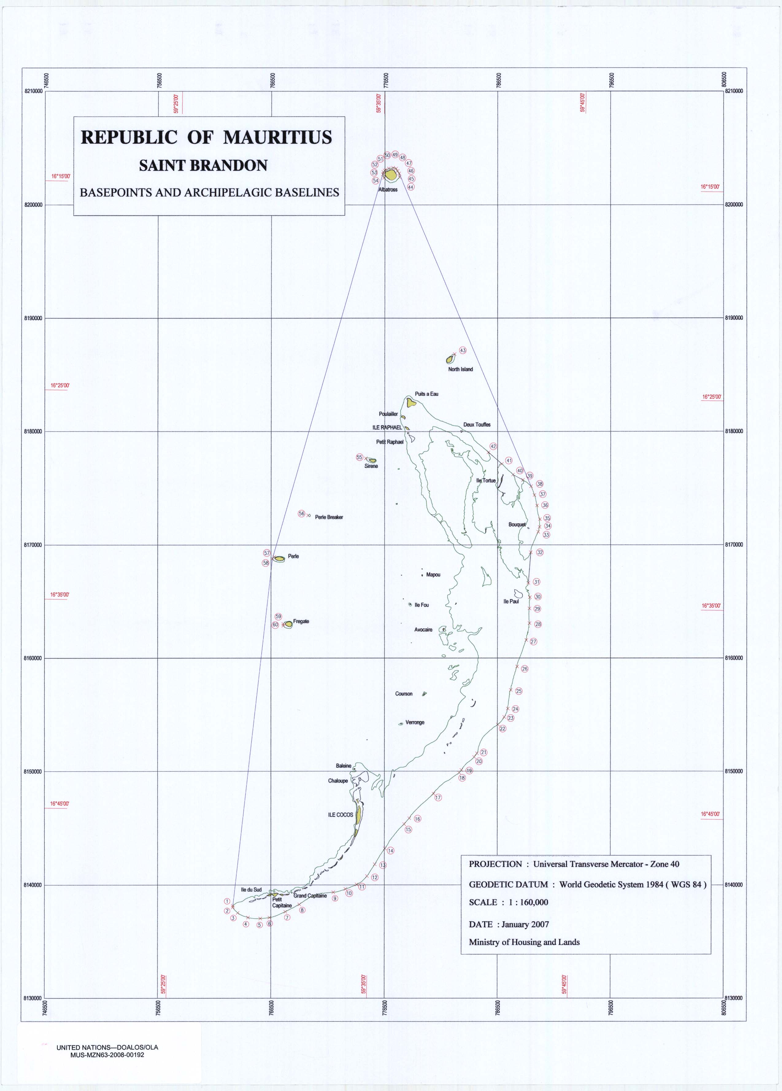
| Main island | Île Raphael |
| Total land area | 3.2 km² |
| Residents | uninhabited |

The Cargados Carajos Islands ( English Cargados Carajos Shoals ) also Saint Brandon are an archipelago with an extensive reef in the Indian Ocean , 407 kilometers (Coco Island - Mauritius) northeast of Mauritius (Coco Island - Port Louis 431 km). They are located on the submarine Mascarene Plateau and are therefore part of the Mascarene archipelago .
Its land area is only around 3.2 km², the reef extends over 65.5 km in north-south direction with a width of around 21 km, thus covering an area of around 1,356 km². Almost all of the islands rise out of the sea west of this reef. They form the remains of a submerged volcano .
Politically, the Cargados-Carajos Islands are an area dependent on Mauritius and are administered directly by the government in Port Louis . The census in 2000 shows no permanent population for the archipelago, but 63 people were on Cargados Carajos at the time of the census. The islands are used as a fishing base, the mining of guano and copra production are further sources of income. The islands are covered with coral sand, in many places there is a thick layer of guano. Sea turtles use the beaches to lay their eggs.
The archipelago was probably discovered by Arab sailors in the 7th century. It got its name in 1506 from Portuguese sailors on their way to India . In 1598 the islands were conquered by the Dutch, in 1722 a French protectorate, came into British hands in 1810 and became part of the independent Mauritius in 1968.
On the second stage of the Volvo Ocean Race 2014–2015 , the Vestas Wind team ran into a reef on the Cargados-Carajos Islands on November 29, 2014. The team was saved unharmed.
The bigger islands
The following table lists the larger islands according to their geographical location (from north to south).
| Surname | location | Remarks |
|---|---|---|
| Albatross Island | 16 ° 13'43 "S, 59 ° 35'15" E | Area 1.01 km², at 6 m above sea level. d. Sea level highest point, uninhabited since 1988 |
| Îlot du Nord (North Iceland) | 16 ° 19S, 59 ° 39'E | |
| Île Raphael | 16 ° 27'S, 59 ° 37'E | largest population (> 35); Fishing, weather station, coast guard |
| Îlot siren | 16 ° 28'S, 59 ° 34'E | |
| Ile Tortue | 16 ° 28'S, 59 ° 41'E | |
| Pearl Islet (Île Perle) | 16 ° 31'S, 59 ° 32'E | |
| Île du Sud | 16 ° 32'S, 59 ° 32'E | some temporary residents |
| Avocare Island (Avoquer) | 16 ° 35'S, 59 ° 40'E | some temporary residents |
| Mapare Islet | 16 ° 35'S, 59 ° 41'E | |
| Frigate Islet (Île Frégate) | 16 ° 37'S, 59 ° 31'E | |
| Îlote du Paul | 16 ° 37'S, 59 ° 33'E | |
| Baleine Rocks | 16 ° 41'S, 59 ° 30'E | |
| Île Veronge (Verronge) | 16 ° 41'S, 59 ° 37'E | |
| Veronge Îlot | 16 ° 42'S, 59 ° 38'E | |
| Palm Islet | 16 ° 45'S, 59 ° 35'E | |
| Coco Island (Île aux Cocos) | 16 ° 48'07 "S, 59 ° 32'44" E | some temporary residents, weather station |
| Grande Capitane | 16 ° 40'S, 59 ° 50'E | |
| Petite Capitane | 16 ° 36'S, 59 ° 34'E | |
| Puits A Eau | 16 ° 39'S, 59 ° 34'E | |
| Ile Poulailer | 16 ° 44'S, 59 ° 46'E | |
| Chaloupe | 16 ° 49'S, 59 ° 50'E | |
| Courson | 16 ° 48'S, 59 ° 30'E |
Climate table
| St. Brandon (Cargados Carajos Islands) | ||||||||||||||||||||||||||||||||||||||||||||||||
|---|---|---|---|---|---|---|---|---|---|---|---|---|---|---|---|---|---|---|---|---|---|---|---|---|---|---|---|---|---|---|---|---|---|---|---|---|---|---|---|---|---|---|---|---|---|---|---|---|
| Climate diagram | ||||||||||||||||||||||||||||||||||||||||||||||||
| ||||||||||||||||||||||||||||||||||||||||||||||||
|
Average Monthly Temperatures and Rainfall for St. Brandon (Cargados Carajos Islands)
Source: wetterkontor.de
|
|||||||||||||||||||||||||||||||||||||||||||||||||||||||||||||||||||||||||||||||||||||||||||||||||||||||||||||||||||||||||||||||||||||||
Individual evidence
- ↑ Mauritius Census 2000 ( Memento from November 21, 2009 in the Internet Archive ) (English)
- ↑ Grounded . Archived from the original on December 5, 2014. Info: The archive link was automatically inserted and not yet checked. Please check the original and archive link according to the instructions and then remove this notice. Accessed November 30, 2014. (English)
Web links
Districts:
Black River |
Flacq |
Grand Port |
Moka |
Pamplemousses |
Plaines Wilhems |
Port Louis (District) |
Rivière du Rempart |
savannah
Cities:
Beau Bassin-Rose Hill |
Curepipe |
Port Louis (city) |
Quatre Bornes |
Vacoas-Phoenix
Dependent islands:
Agalega |
Cargados Carajos |
Rodrigues