Offenbach-Carl-Ulrich-Siedlung
|
Carl Ulrich settlement
City of Offenbach am Main
Coordinates: 50 ° 4 ′ 56 ″ N , 8 ° 46 ′ 18 ″ E
|
|
|---|---|
| Height : | 112 m above sea level NHN |
| Area code : | 069 |
|
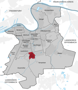
Location of Carl-Ulrich-Siedlung in Offenbach am Main
|
|
|
The St. Konrad Church in the Carl Ulrich settlement
|
|
Carl-Ulrich-Siedlung is a district of the southern Hessian city Offenbach am Main . Along with eleven other districts, it was formed in July 2019 from the area that had previously been free of districts.
location
Carl-Ulrich-Siedlung is in the middle of Offenbach. In the north it borders on Lauterborn , to the west on Rosenhöhe . In the south and east it is surrounded by Tempelsee and briefly touches Buchhügel in the northeast .
Infrastructure
The Anne Frank School is the district's primary school . Around 210 students are looked after by 17 teachers. The school is a project school for German and PC as well as certified in traffic education as part of “School and Health”.
Carl-Ulrich-Siedlung is served by city bus lines of Offenbacher Verkehrs-Betriebe in the local public transport system.
Web links
Individual evidence
- ^ Statutes for the definition and naming of the districts in the area of the city of Offenbach am Main. In: offenbach.de. July 15, 2019, accessed August 20, 2019.
- ^ Magistrate of the City of Offenbach am Main - Surveying Office: Annex to the district statute - map. In: offenbach.de. June 11, 2019, accessed August 25, 2019.
- ^ Anne Frank School. In: offenbach.de. 2019, accessed September 12, 2019 .

