
Offenbach-Lauterborn
|
Lauterborn
City of Offenbach am Main
Coordinates: 50 ° 5 ′ 8 " N , 8 ° 45 ′ 32" E
|
|
|---|---|
| Height : | 112 m above sea level NN |
| Residents : | 13,025 (Sep. 30, 2017) |
| Postal code : | 63069 |
| Area code : | 069 |
 Location of Lauterborn in Offenbach am Main
|
|
Lauterborn is a district of the southern Hessian city Offenbach am Main . Around 13,000 people lived in this district in September 2017.
The district is located in the southwest of Offenbach. It is bounded in the southwest by the city forest, in the west by the federal motorway 661 , in the north by the city district of Städtische Kliniken and in the southeast by the district of Rosenhöhe and the city forest.
history
origin of the name
The Lauterborn refers to a fountain that once stood here. The word Born is an old term for “source”, the word Lauter is an old high German word for “clean”. A “clean spring” still runs under the district, which is no longer shown on city maps.
Construction of the district
In the area of the later part of the city there were, in addition to extensive arable land, some industrial companies, including the Frischauf bicycle factory until 1945 . In the 1960s, the development of the outskirts south of the previous industrial belt began. On the bottom of the Lauterbornwiesen , the Lauterborn district was created, which extends in the south to the Rosenhöhe district and the city forest and is bordered by Sprendlinger Landstrasse in the west. In Lauterborn, like in Frankfurt's north-west town , the linear construction was used to give residents even access to air, sun and green spaces.
In addition to four large point buildings (in Bethnal-Green-Strasse, Mödlingstrasse, Eschstrasse and St. Gilles Strasse), there are dozens of smaller residential units and apartment buildings, most of which are adjacent to the central John F. Kennedy Promenade park . Model houses by the architect Egon Eiermann were built on Johann-Strauss-Weg, the furnishings were designed by his wife Charlotte Eiermann.
A shopping arcade and two commercial buildings were built in the middle of the district between Richard-Wagner-Strasse and Hugo-Wolf-Strasse. The adjacent, today's Europaplatz was initially a purely public parking lot, the place got its name in the 1990s with the construction of a residential complex with an underground car park below.
Handelplatz was never made into a public square, but has served as a two-storey garage since its construction in 1972.
Three schools and two day-care centers were built in the district :
- the Lauterborn School
- the Ludwig-Dern-School and
- the August-Bebel-Schule ( vocational school in the Offenbach district)
such as
- the kindergarten of the Paul-Gerhard-Congregation in the Felix-Mendelssohn-Straße and
- the municipal daycare center 8 in Johann-Strauss-Weg.
Right next to it is the Lauterborn youth center . Here the young people of the district will find a wide range of leisure activities, such as a youth café and an internet café; there are handicraft courses and workshops as well as a meeting point for young women.
The Lauterborn- / Ludwig-Dern-Schule, built in 1969, was renovated and expanded in 2010, a single-storey part of the building was completely demolished and replaced by a three-storey new building. The school now also offers lunch and childcare within the framework of the Hessian Special Investment Program Act.
Until 2013 Lauterborn had its own Protestant church, the Lauterborn Church. This was demolished in 2014 due to the sharp decline in the proportion of the Protestant resident population.
Many streets bear the names of well-known composers (not a few of whom are related to Offenbach).

Lauterborn School and Ludwig Dern School
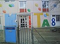
The municipal day care center 8 in Johann-Strauss-Weg

The Lauterborn youth center next to daycare center 8

High-rise complex on the Odenwaldring

Playground design on Richard-Wagner-Strasse

The shopping arcade on Europaplatz (before the renovation)

West entrance of the ring center

Roller skating rink with pipe between Richard-Wagner-Straße and Weidigweg


Structural change
In general, the economic importance of the district is increasing significantly. The closure of some industrial plants and a US barracks left well-developed areas that were built on by new companies. In addition to Honda's European and German headquarters, the 63 (1997) letter center and various supermarkets and office spaces in the parallel streets were built on Sprendlinger Landstrasse . Since the industrial companies were not connected to Lauterborn, the structural change had no direct consequences.
In 1999 the areas of the previous industrial railway were redesigned into a cycle path. After the planning of a southern bypass was abandoned, the Offenbach green belt was created, which touches the district to the south. In the same year, the Ringcenter , a large shopping center , was built on the site of the former Stahlbau Lavis . In 2009 the ring center was expanded because the demand for retail space there had increased.
In 2009 the previous shopping arcade on Richard-Wagner-Straße was rebuilt, as the previous tenants had moved into larger structures (such as the post office in the letter center and a grocery store in a new building). The architect Arthur Mähner from Novotny Mähner Associate was particularly committed to preserving and revitalizing the center of the district for retail trade. He took over the property and organized the renovation. The small-scale and vacant structure was given up in favor of larger areas. A new discounter, a bakery branch and, for the first time, a district center as a citizens' office emerged.
Culture and sights
architecture
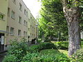
Rows embedded in the park, characteristic of Lauterborn

One of the four point houses

Offset construction

Egon Eiermann's atrium houses

The Evangelical Lauterborn Community

Townhouses

Front view of the apartment house on Europaplatz

Detail of the apartment house on Europaplatz

Apartment house on Richard-Wagner-Strasse by Novotny Mähner Associate

.JPG)
.jpg)


.JPG)

.JPG)
.jpg)
Worth seeing
As an industrial and residential area, Lauterborn does not have any major historical sights, but there are some places worth seeing.
A cycle path leads through Lauterborn on the route of the former industrial railway. Along this is a path with boards and exhibits on Offenbach's industrial history (as part of the Rhein-Main industrial culture route ). The model houses of the famous architect Egon Eiermann are on this path in Johann-Strauss-Weg . However, the atrium is not visible from the street.
The "John F. Kennedy Promenade" crosses this path and is the green area of the district with good trees and various playgrounds, along which the bronze sculpture "Stehende" by Fritz Schwarzbeck is installed.
To the south, the green space leads through allotment gardens into the city forest. There, the district is flanked by the Offenbach green belt, a wide aisle that was kept free until the 1980s as a reserve area for a four-lane expressway and provided space for allotment gardens.

Traces of the former industrial railway on the former route (Johann-Strauss-Weg junction at John F. Kennedy Promenade)
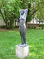
"The Standing Woman" by Fritz Schwarzbeck
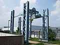
Route of industrial culture: monument next to the former Lavis steel structure

Offenbacher Grünring on the former planned bypass road


Infrastructure
.jpg)
Local transport
The district is connected to the center (S-Bahn station Marktplatz) and the district of Bieber by the bus lines 106, 105 and 104 of Offenbacher Verkehrs-Betriebe . In addition, there is a connection to the Kaiserlei S-Bahn station and the Bürgel and Rumpenheim districts with line 107 .
Trunk roads
In the vicinity of the district, the A 3 and A 661 motorways intersect in the south, and the B 43 and B 46 federal highways form the northern border.
Web links
Individual evidence
- ↑ a b Residents of the city of Offenbach am Main according to statistical districts on September 30, 2017. (PDF; 29 kB) City of Offenbach am Main, accessed on November 26, 2017 .
- ^ Sonja Günther: The fifties: interior architecture and living design , DVA 1994, p. 160
- ↑ Lauterborn Youth Center. ( Memento from April 30, 2016 in the Internet Archive ) In: offenbach.de , accessed on April 30, 2016.
- ↑ Madeleine Reckmann: Lauterborn: excavators nibble on the church. In: fr-online.de. January 28, 2014, accessed June 11, 2015 .
Beaver | Bieberer Berg | Book Hill | Buchrain | Bürgel | Carl Ulrich Estate | Port | Kaiserlei | Lauterborn | Lindenfeld | Mathildenviertel | Musicians' quarter | Northrend | Offenbach-East | Rosenhöhe | Rumpenheim | Senefelderquartier | Temple Lake | Waldheim | Westend | center