Offenbach-Senefelderquartier
|
Senefelderquartier
City of Offenbach am Main
Coordinates: 50 ° 5 ′ 50 ″ N , 8 ° 45 ′ 41 ″ E
|
|
|---|---|
| Height : | 118 m above sea level NHN |
| Residents : | 8251 (Jun 30, 2020) |
| Area code : | 069 |
|
Location of Senefelderquartier in Offenbach am Main
|
|
|
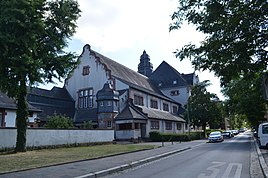
The Albert Schweitzer School in the Senefelder district
|
|
Senefelderquartier is a district of the southern Hessian city Offenbach am Main . Along with eleven other districts, it was formed in July 2019 from the area that had previously been free of districts.
Around 8,250 people lived in this district in June 2020.
location
Senefelderquartier lies north of the musicians' quarter and is separated from it by the system ring . Behind the route of the Frankfurt-Bebraer Railway , Westend and Center join in the north . To the west lies Buchrain , east Linde field .
Infrastructure
The Albert Schweitzer School is located in Senefelderquartier . The grammar school was originally founded as a "Higher Daughter School" and has had its current name since 1956. The school is a UNESCO project school and a school sports center in cooperation with primary schools, secondary schools and associations.
Landesstraße 3001 runs along the western edge of the quarter and connects with Fechenheim and Neu-Isenburg as well as the BAB 3 . Senefelderquartier is connected to the trunk road network via this.
Offenbach Central Station is on the northern edge of the district . Since the S-Bahn opened, it has only been of secondary importance. There are only regional connections to destinations within Hesse and Bavaria . The district is in the public transport of city bus lines of the Offenbacher of transporting enterprises developed.
Web links
Individual evidence
- ↑ a b Residents of the city of Offenbach am Main by district on June 30, 2020. (PDF; 17 kB) City of Offenbach am Main, June 30, 2020, accessed on August 18, 2020 .
- ^ Statutes for the definition and naming of the districts in the area of the city of Offenbach am Main. In: offenbach.de. July 15, 2019, accessed August 20, 2019.
- ^ Magistrate of the City of Offenbach am Main - Surveying Office: Annex to the district statute - map. In: offenbach.de. June 11, 2019, accessed August 25, 2019.

