Carmelo (Uruguay)
| Carmelo | ||
|---|---|---|
|
Coordinates: 34 ° 0 ′ S , 58 ° 17 ′ W Carmelo on the map of Uruguay
|
||
| Basic data | ||
| Country |
|
|
| Department | Colonia | |
| City foundation | February 12, 1816 by José Gervasio Artigas | |
| Residents | 18,041 (2011) | |
| City insignia | ||
| Detailed data | ||
| height | 23 m | |
| Post Code | 70100 | |
| prefix | +0542 | |
| City Presidency | Alejandro Brusco | |
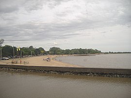
| Carmelo Beach | ||
| Central square in Carmelo | ||
Carmelo is a city in southwest Uruguay .
geography
Carmelo is in the area of the Department of Colonia in its sector 6 at the mouth of the Arroyo de las Vacas , on the northern, right bank of which the city is located, in the Río de la Plata . On the Rio de la Plata side, to the west, the Paraná Delta extends . The distance to the departmental capital Colonia , southeast of Carmelo, is 75 kilometers, while the state capital Montevideo is around 235 kilometers to the east. To the northwest of Carmelo are the town of Zagarzazú and the town of Nueva Palmira .
history
The city was founded on February 12, 1816 by José Gervasio Artigas . On August 17, 1920, due to the Ley No. 7.257 the classification of Carmelos as Ciudad (city).
Infrastructure
education
Carmelo has two secondary schools ( Liceo ). These are the Liceo Nº 1 de Carmelo "Dr. David Bonjour", founded in 1931, and the Liceo Nº 2 de Carmelo (Liceo de Bachillerato), which has existed since March 24, 2003 .
Culture
Once a year in February, the wine festival called Festival Nacional de la Uva takes place in Carmelo, which is located in a wine-growing region .
traffic
In terms of traffic, the city is connected to the national road network and thus also to interdepartmental bus services via the Ruta 21 , which connects the cities of Mercedes and Colonia and runs through Carmelo . Regular line connections exist with Colonia, Montevideo, Mercedes, Fray Bentos, Paysandú and Salto via the company Chadre . Carmelo also has its own airport , where in 2009 a total of 2700 aircraft movements, including 2000 international flights and 700 domestic flights, with 2350 passengers (1900 international, 450 national) were registered. There is also an important port in the city, through which regular ferry traffic with the Argentine city of Tigre is handled.
Economy and sights
The center of the city is the Plaza Independencia , while the street of April 19 ("19 de Abril") is the main shopping street and is connected to the bridge crossing of the Arroyo de las Vacas to a recreational area south of the city. By the River de las Vacas is the Playa Seré a swimming beach. From a cultural point of view, the Archivo y Mudeo Parroquial , which is oriented towards local history , and the Santuario del Carmen church, built in 1830, are worth mentioning .
Population and population development
With a population of 18,041 (as of 2011), of which 8,545 are male and 9,496 female, it is the second largest city in the department.
| year | Residents |
|---|---|
| 1963 | 12,680 |
| 1975 | 13,707 |
| 1985 | 14,278 |
| 1996 | 16,658 |
| 2004 | 16,866 |
| 2011 | 18,041 |
Source:
climate
Carmelo is in a temperate climate zone, with temperatures between 3 and 5 ° C in winter and an average of 25 ° C in spring and summer.
City administration
Mayor ( Alcalde ) of Carmelo is Alejandro Brusco .
sons and daughters of the town
- Miguel Andreolo (1912–1981), football player
- Juan Francisco Aragone (1883–1953), Archbishop of Montevideo
- Roberto Bertolino , writer
- Daniel Bianchi , physician and politician
- Atilio François Baldi (1922–1997), cyclist, called El León del Carmelo (= The Lion of Carmelo )
- Ismael Espiga (* 1978), football player
- Juan Carlos Mareco (1926–2009), "Pinocho" - actor and comedian
- Gonzalo Pérez Iribarren (1936–1998), mathematician
- José Reinoso (* 1971), jazz musician
- Bernardo Roselli (* 1965), chess player
- Fabricio Silva (* 1990), football player
- Lilián Zetune (* 1940), choirmaster
Web links
- Information about the place (English)
Individual evidence
- ↑ Information about Carmelo on guiacolonia.com.uy ( Memento of the original from September 23, 2010 in the Internet Archive ) Info: The archive link was inserted automatically and has not yet been checked. Please check the original and archive link according to the instructions and then remove this notice.
- ↑ Liceos del Uruguay (Spanish) (PDF; 7.3 MB), accessed on February 29, 2012
- ↑ Report on airport occupancy at ultimasnoticias.com.uy
- ^ "Argentina (and Falkland Islands)", p. 80 by Rolf Seeler, Juan Garff
- ^ Website of the ferry company Cacciola SA
- ^ "Argentina", p. 561f by Sandra Bao, Gregor Clark, Andy Symington, Bridget Gleeson, Lucas Vidgen
- ^ "The Rough Guide to South America", p. 997 by Harry Adès, Rough Guides
- ^ "Argentina", p. 652 by Danny Palmerlee
- ↑ Statistical data from the Instituto Nacional de Estadística de Uruguay , accessed on September 28, 2012
- ↑ Statistical data of the Instituto Nacional de Estadística de Uruguay 1963–1996 ( MS Word ; 176 kB)
- ↑ Statistical data of the Instituto Nacional de Estadística de Uruguay 2004 (PDF; 494 kB)
- ↑ "MUNICIPIOS DE URUGUAY" on the website of the Uruguayan Congress of Directors ( Memento of March 8, 2012 in the Internet Archive )


