Chiang Khan Amphoe
|
Chiang Khan เชียงคาน |
|
|---|---|
| Province: | Loei |
| Surface: | 867.0 km² |
| Residents: | 60,283 (2013) |
| Population density : | 68.1 U / km² |
| ZIP : | 42110 |
| Geocode : | 4203 |
| map | |

|
|
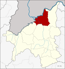
Amphoe Chiang Khan ( Thai : อำเภอ เชียงคาน , pronunciation: ʔāmpʰɤ̄ː tɕʰīaŋ kʰāːn ) is a district ( amphoe - administrative district) in the north of Loei Province . The province of Loei is located in the northwestern part of the northeast region of Thailand , the so-called Isan .
geography
Neighboring counties and areas are (clockwise from east): Pak Chom , Mueang Loei, and Tha Li district in Loei Province. In the northwest lies the Sayaburi province of the Lao People's Democratic Republic .
Important water resources are the following rivers: Mekong ( แม่ โขง , [ mɛ̂ː kʰǒːŋ ]), Lam Nam Hueang ( ลำน้ำ เหื อง , Hueang Waterway ) and Mae Nam Loei ( แม่น้ำ เลย , Loei River ).
history
Attractions
- Kaeng Khut Khu (Thai: แก่ง คุดคู้ , winding rapids ) - rapids in the Mekong with multicolored, smoothly polished rocks.
administration
Provincial Administration
Chiang Khan County is divided into eight tambon ("subdistricts" or "parishes"), which are further subdivided into 82 muban ("villages").
| No. | Surname | Thai | Muban | Pop. |
|---|---|---|---|---|
| 1. | Chiang Khan | เชียงคาน | 6th | 10,269 |
| 2. | That | ธาตุ | 16 | 9,831 |
| 3. | Well Sao | นา ซ่า ว | 15th | 11,457 |
| 4th | Khao Kaeo | เขา แก้ว | 13 | 7,790 |
| 5. | Pak Tom | ปาก ต ม | 8th | 6.215 |
| 6th | Bu Hom | บุ ฮ ม | 11 | 7,850 |
| 7th | Chom Si | จอม ศรี | 8th | 4,300 |
| 8th. | Has Sai Khao | หาด ทรายขาว | 5 | 2,571 |
Local administration
There are three municipalities with "small town" status ( Thesaban Tambon ) in the district:
- Chiang Khan (Thai: เทศบาล ตำบล เชียงคาน ) consisting of parts of the Tambon Chiang Khan.
- Khao Kaeo (Thai: เทศบาล ตำบล เขา แก้ว ) consisting of the complete Tambon Khao Kaeo.
- That (Thai: เทศบาล ตำบล ธาตุ ) consisting of the complete Tambon That.
There are also six " Tambon Administrative Organizations " ( องค์การ บริหาร ส่วน ตำบล - Tambon Administrative Organizations, TAO):
- Chiang Khan (Thai: องค์การ บริหาร ส่วน ตำบล เชียงคาน ) consisting of parts of the Tambon Chiang Khan.
- Na Sao (Thai: องค์การ บริหาร ส่วน ตำบล นา ซ่า ว ) consisting of the complete Tambon Na Sao.
- Pak Tom (Thai: องค์การ บริหาร ส่วน ตำบล ปาก ต ม ) consisting of the complete Tambon Pak Tom.
- Bu Hom (Thai: องค์การ บริหาร ส่วน ตำบล บุ ฮ ม ) consisting of the complete tambon Bu Hom.
- Chom Si (Thai: องค์การ บริหาร ส่วน ตำบล จอม ศรี ) consisting of the complete tambon Chom Si.
- Hat Sai Khao (Thai: องค์การ บริหาร ส่วน ตำบล หาด ทรายขาว ) consisting of the complete tambon Hat Sai Khao.
Individual evidence
- ↑ 2013 population statistics ( Thai ) Department of Provincial Administration. Retrieved July 29, 2014.
Web links
- More details on Amphoe Chiang Khan from amphoe.com (in Thai)
- http://www.chiangkhan.org/ (in Thai)
Coordinates: 17 ° 54 ' N , 101 ° 40' E

