Chillia district
| Chillia district | |
|---|---|
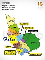
 The Chillia district (marked in yellow) is located in the west of the Pataz province |
|
| Basic data | |
| Country | Peru |
| region | La Libertad |
| province | Pataz |
| Seat | Chillia |
| surface | 309 km² |
| Residents | 11,678 (2017) |
| density | 38 inhabitants per km² |
| founding | December 29, 1856 |
| ISO 3166-2 | PE-LAL |
| Website | munichillia.gob.pe (Spanish) |
| politics | |
| Alcalde District | Julio Henríquez Graciano (2019-2022) |
| Political party | Partido Democracia Directa |
| Plaza de Armas in Chillia | |
Coordinates: 8 ° 7 ′ S , 77 ° 31 ′ W
The district of Chillia , alternative spelling: District Chilia , is located in the province of Pataz in the La Libertad region in western Peru . The district was established on December 29, 1856. It has an area of 309 km². The 2017 census counted 11,678 inhabitants. In 1993 the population was 9537, in 2007 it was 12,043. The administrative seat of the district is the 3118 m high village of Chillia with 1660 inhabitants (as of 2017). Chillia is just under 30 km northwest of the provincial capital Tayabamba .
Geographical location
The Chillia district is located on the western flank of the Peruvian Central Cordillera in the west of the Pataz province. The district has a lengthwise extension in NW-SE direction of about 23 km and a width of about 13 km. The Río Marañón flows north along the western district boundary. In the south, its tributary Río Cajas forms the district boundary.
Web links
- Municipalidad Distrital de Chillia
- Peru: Region La Libertad (provinces and districts) at www.citypopulation.de
- INEI Perú
