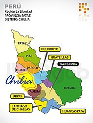
Ongón District
| Ongón District | |
|---|---|
 The district of Ongón (dark green) is located in the east of the province of Pataz |
|
| Basic data | |
| Country | Peru |
| region | La Libertad |
| province | Pataz |
| Seat | Ongón |
| surface | 1312 km² |
| Residents | 1401 (2017) |
| density | 1.1 inhabitants per km² |
| founding | November 25, 1876 |
| ISO 3166-2 | PE-LAL |
| politics | |
| Alcalde District | Eleuterio López Miranda (2019-2022) |
| Political party | Alianza para el Progreso |
Coordinates: 8 ° 12 ′ S , 76 ° 59 ′ W
The Ongón district is located in the Pataz Province in the La Libertad region in western Peru . The district was founded on November 25, 1876. It has an area of 1312 km². The 2017 census counted 1401 inhabitants. In 1993 the population was 1525, in 2007 it was 1694. The district administration is located in the village of Ongón, which is around 1100 m high and has 149 inhabitants (as of 2017). Ongón is 35 km east of the provincial capital Tayabamba .
Geographical location
The Ongón district extends over the east of the Pataz province, east of the Peruvian Central Cordillera . The main ridge of the mountains runs along the western district boundary. The very sparsely populated area is drained to the east via the Río Mishollo .
The district of Ongón borders in the west on the districts Tayabamba , Huaylillas and Buldibuyo , in the north on the district Huicungo ( province Mariscal Cáceres ), in the northeast on the district Pólvora ( province Tocache ) and in the southeast on the Shunte (also in the province Tocache) .
Web links
- Peru: Region La Libertad (provinces and districts) at www.citypopulation.de
- INEI Perú
