Pias district
| Pias district | |
|---|---|
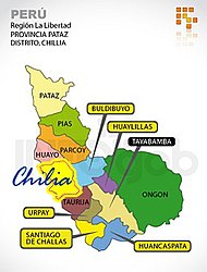
 The district of Pias (light green) is located in the northwest of the province of Pataz |
|
| Basic data | |
| Country | Peru |
| region | La Libertad |
| province | Pataz |
| Seat | Pias |
| surface | 310 km² |
| Residents | 1790 (2017) |
| density | 5.8 inhabitants per km² |
| founding | October 31, 1955 |
| ISO 3166-2 | PE-LAL |
| politics | |
| Alcalde District | Amaro Cueva Salvatierra (2019-2022) |
Coordinates: 7 ° 52 ′ S , 77 ° 33 ′ W
The district of Pias is located in the province of Pataz in the La Libertad region in western Peru . The district was established on October 31, 1955. It has an area of 310 km². The 2017 census counted 1790 inhabitants. In 1993 the population was 1930, in 2007 it was 1525. The district administration is located in the 2630 m high village of Pias with 533 inhabitants (as of 2017). Pias is about 53 km north-northwest of the provincial capital Tayabamba .
Geographical location
The Pias District is located in the northwest of the Pataz Province. It extends between the Río Marañón in the west and the main ridge of the Peruvian Central Cordillera in the east. The rivers Río San Miguel and Quebrada Carrizal limit the district in the southwest and in the northwest. To the south of the district is the Lago Piaz lake.
The Pias district borders on the Cochorco district ( Sánchez Carrión province ) to the west, the Pataz district to the north, the Huicungo district ( Mariscal Cáceres province ) to the east and the Parcoy district to the south .
Web links
- Peru: Region La Libertad (provinces and districts) at www.citypopulation.de
- INEI Perú