
Chorbrünnel circular route
| Chorbrünnel circular route | |
|---|---|
 Logo of the circular route |
|
| Data | |
| length | 3.5 km |
| location | Leiningerland ( Vorderpfalz , Rhineland-Palatinate ) |
| Markers | an orange stone arcade with a red-blue fountain symbol on a green background |
| Start / finish point | Dirmstein Castle Square 49 ° 33 ′ 48 ″ N , 8 ° 14 ′ 51 ″ E |
| Type | trail |
| Height difference | 25 m |
| The highest point | 133 m |
| Lowest point | 108 m |
| Level of difficulty | light |
| season | all year round |
| Viewpoints | Hill (139 m) next to the highest point of the route |
| particularities | various inner-city cultural monuments, out of town the natural monuments Wörschberger Hohl and Chorbrünnel |
The Chorbrünnel-Rundweg is a 3.5 km long circular hiking trail that connects regional attractions in the east of Leiningerland that are within and northwest of the residential development of the Rhineland-Palatinate municipality of Dirmstein . The green signs show an orange-yellow stone arcade with the red-blue symbol of a fountain.
geography
The way there and back are identical within Dirmstein. The part of the route outside the residential area runs clockwise; it was approved by the local environmental association "Alte Sandkaut" Dirmstein e. V. made accessible and provided with benches, information boards and path signs. The circular route initiated by the local environmental protection association Alte Sandkaut was opened in spring 2006.
The profile of the circular route is slightly hilly; From 108 m it rises mainly slightly on the first third of the route to 133 m and then drops moderately to the starting level. It takes about 90 minutes to walk the entire route.
Attractions
In the town
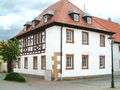
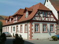
The circular route begins in the center of the Dirmsteiner Oberdorf on the Schlossplatz at Sturmfeder Castle . North-east of the square is the oldest house , which survived the burning down of the place by French troops in 1689 with a few others. Diagonally across the street, in Franz Rothermel's house , lived the master builder who built the baroque Laurentius Church in the 1740s . Passing the restored bakery from 1730, the Jesuitenhof , which was run by monks for 300 years from 1500 , the Quadtschen Castle , whose predecessor was a provost of the Augustinian order in the Middle Ages , and the Koeth-Wanscheidschen Castle , you reach the castle park . It was planned around 1830 by the landscape architect Johann Christian Metzger and laid out in the style of an English garden . On the corner of Landesstraße 453 is the restored garden pavilion , which originally belonged to the Jesuitenhof, with the sgraffiti by Walter Perron from around the middle of the 20th century .
Wörschberger Hohl
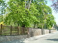
After crossing the state road, where the loess walls protected as a monument run a few meters to the left of the transition , Lindesheimer Straße leads to the natural monument Wörschberger Hohl northwest of the community. As the name suggests, it is a ravine . Its extension leads to the Wörschberg, about 1 km away and 165 m high . Due to erosion as a result of centuries of use by carts, the path has dug itself deep into the hilly and gently sloping landscape here. It is characterized by vertical loess walls that are up to 6 m high and represent a biotope for numerous species of heat-loving insects , cave-breeding birds as well as wild rabbits and foxes .
At the highest point of the route, which is on the ravine at 133 m , on the side of a hilltop at 139 m , there are opportunities to look out over the Rhine plain , which extends in the east to the opposite Odenwald , and to the west over the vine hills to the edge of the Palatinate Forest . From the highest point, the path descends again slightly to the Floßbach , which winds through a bed also dug deep into the loess layers to flow east of Dirmstein into the Eckbach .
Chorbrünnel
Another natural monument, Chorbrünnel , is located 600 m further from the vantage point on the other side of the Floßbach . This small, dry fallen since 2005 wells on 124 m height was from a sulfur spring fed. The well chamber, built in the first half of the 16th century by the Jesuit monks from Dirmstein , discharged the water into a tub that was also made of stone in front of it, which enabled baths for healing purposes; the overflow flowed into the raft stream after a few meters. The keystone of the vault bears the date 1733, later added.
From the Chorbrünnel the circular route leads along the Floßbach to the east and then to the south via Lindesheimer Straße back to the starting point in Dirmstein.
Stations

Start on the Schlossplatz ...
Oldest house ...
Bakehouse ...

Jesuit Court ...
Castle Park ...

Goal 1:
Wörschberger Hohl
Floßbach :
deeply cut ...
... and sometimes foaming white

Goal 2:
Chorbrünnel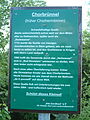
Information board at the Chorbrünnel


Web links
- Location of the Chorbrünnels on: Map service of the landscape information system of the Rhineland-Palatinate Nature Conservation Administration (LANIS map) ( information )
- Gerald Friederici: A short walk near Dirmstein (PDF; 298 kB)
Individual evidence
- ↑ a b c d Map service of the landscape information system of the Rhineland-Palatinate nature conservation administration (LANIS map) ( notes )
- ↑ a b Alte Sandkaut e. V .: Chorbrünnel . Dirmstein 2006 (information board on site).