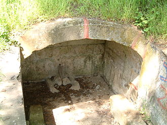
Choir fountain
| Choir fountain | |
|---|---|
| Chorbrünnel | |
| place | Dirmstein |
| country |
|
| use | Medicinal purposes, bathing, sales |
| construction time | first half of the 16th century; Current form: 1733 |
| Architectural style | Late baroque |
| Coordinates | |
| location | Coordinates: 49 ° 34 ′ 21.5 " N , 8 ° 14 ′ 18.2" E 49 ° 34 ′ 21.5 " N , 8 ° 14 ′ 18.2" E |
Officially Chorbrunnen , on site only Chorbrünnel is the name of a natural monument with the list number ND-7332-520 in the field mark of the Rhineland-Palatinate municipality of Dirmstein . The fountain is next to the Wörschberger hollow , the main objective of the 2006 opened Chorbrünnel circular path .
Geographical location
The Chorbrünnel is located almost 500 m northwest of the Dirmstein residential development at 124 m above sea level. NHN left of the Floßbach , a left tributary of the Eckbach . A stone staircase with 15 steps leads from the slightly higher circular path down to the fountain. State road 455 runs from Dirmstein to Offstein about 600 m to the east, and state road 453 to Obersülzen is just as far south .
Plant and history
The little fountain has made sandstone brick chamber and was until 2005 dry fell from a sulfur- containing source fed. The water from the actual sulfur spring mixed with the pouring from seven other springs without sulfur content, which significantly weakened the sulfur taste. The well water was exposed until the end of the Middle Ages and was used for healing purposes.
In the first half of the 16th century, the Dirmstein Jesuits led the spring water via a covered canal , which has five cleaning boxes over its length of 130 m, to the well chamber built at that time near the Floßbach flowing past on the right. A tub , also made of stone , took the water flowing out of the chamber and also made baths possible. The overflow flowed into the raft stream after a few meters. The keystone of the vault bears the date 1733, later added; Renovation work may have taken place at the time. The source was initially called "Chorherrnbronn" after the monastery lords; the name ground itself in the course of time to the "Chorbrünnel".
Web links
- Location of the Chorbrünnels on: Map service of the landscape information system of the Rhineland-Palatinate Nature Conservation Administration (LANIS map) ( information )
- Gerald Friederici: Short historical hike near Dirmstein / Frankenthal
Individual evidence
- ↑ Nature Conservation Administration Rhineland-Palatinate: Landscape Information System of the Nature Conservation Administration Rhineland-Palatinate. Retrieved September 27, 2013 .
- ↑ Map service of the landscape information system of the Rhineland-Palatinate nature conservation administration (LANIS map) ( notes )
- ↑ a b Alte Sandkaut e. V .: Chorbrünnel . Dirmstein 2006 (information board on site).


