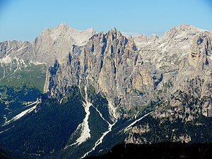
Cima Scalieret
| Cima Scalieret | ||
|---|---|---|
|
Rosengartenspitze (back left), Gran Cront (front center) and Cima Scalieret (back right) |
||
| height | 2887 m slm | |
| location | Trentino , Italy | |
| Mountains | Rosengarten Group , Dolomites | |
| Dominance | 0.65 km → Larsech | |
| Notch height | 98 m ↓ Pas de Scalieret | |
| Coordinates | 46 ° 27 '49 " N , 11 ° 38' 39" E | |
|
|
||
| First ascent | 1868 by Gottfried Seelos , Ignaz Seelos and Karl Moser | |
| Normal way | From Vigo di Fassa through the Vajolettal | |
The Cima Scalieret is a 2887 m slm high mountain on the side of the Rosengarten group in the Italian province of Trentino in the Dolomites . It is located east of the upper Vajolettal , which is in the center of the Rosengarten group, in the area of the former municipality of Pozza di Fassa .
topography
The mountain falls to the east, south and west in moderately steep, relatively small rock walls and fields of rubble and scree into the Valojettal in the west and to the Larsechtal in the east and south. To the north, a ridge dissolves from the summit, which leads to the Pas de Scalieret , which connects the Cima Scalieret with the Larsech .
Alpinism
The first ascent of Cima Scalieret took place in 1868 by the painter Gottfried Seelos and his brother Ignaz Seelos , accompanied by Karl Moser . When they explored the valleys of the Rosengarten group at the beginning of the second half of the 19th century , they climbed the Cima Scalieret in the then still untouched Rosengarten group for the first time, which is considered the first tourist summit ascent in the Rosengarten group.
Today's normal route leads from Vigo di Fassa either on path no.544 or with a gondola to Rifugio Ciampedie and then on path no.540 to Rifugio Gardeccia , where path no.546 now easily over the meadows and scree fields of the upper one Vajolettals leads to the Vajolet hut . Now follow marker 584 to the Grasleitenpasshütte on the Grasleitenpass - the last refuge on the way - from which you hike over the north ridge of the Cima Scalieret on a marked trail to the summit ascent, which is pathless, but is easy to manage with the appropriate surefootedness .
Other options for climbing the Cima Scalieret lead from Tiers in South Tyrol through the Tschamin Valley and the Grasleitental to the Grasleiten Pass and then on to the summit as described above. It is also possible to climb from Pozza di Fassa or Mazzin as well as a variation in which you climb from the Vajolet hut to the Pas da le Pope between Cima Scalieret and the small summit of Le Pope and then come to the summit via the southern flank of the mountain .
Individual evidence
- ↑ a b Kompass Maps , Trentino, sheet 683, map 1, 1: 50000
- ↑ Casa Editrice Tabacco , Val di Fassa e Dolomiti Fassane, sheet 06, 1.25000
- ↑ Rudi Wutscher: Normalwege in den Dolomiten, Tappeiner, Bozen, ISBN 978-88-7073-502-4 , pp. 14-16

