Cloridenberg
| Cloridenberg | ||
|---|---|---|
|
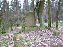
View from the direction of Klare Grete to the Cloridenberg |
||
| height | 124.6 m above sea level NHN | |
| location | near Calvörde ; Borde district , Saxony-Anhalt ( Germany ) | |
| Mountains | Calvör Mountains | |
| Coordinates | 52 ° 21 '30 " N , 11 ° 16' 59" E | |
|
|
||
The Cloridenberg is 124.6 m above sea level. NHN high elevation of the Calvör Mountains . It is located in the south of the municipality of Calvörde in the Saxony-Anhalt district of Börde .
geography
location
The Cloridenberg rises in the central part of the Calvörde mountains and in the elongated southern tip of the municipality of Calvörde . Its summit is 4.2 km south-south-west of the Calvörde core town, 2.6 km west of Wieglitz , a district of Bülstringen , and 1.9 km northeast of Flechtingen Bahnhof and 2.5 km east -south- east of Böddensell , two districts of Flechtingen .
The landscape drops to the east over the Mittelland Canal, which runs on the lower slope of the elevation and east of Wieglitz, to the Elbe tributary Ohre , which flows a little beyond it to the south-southeast ; to the west it drops past Flechtingen train station and Böddensell to Streenriethe (Streen-Riethe) , which flows west of Böddensell into the Aller tributary Spetze, which flows north-west there .
To the north is the Mörderberg ( 116.8 m ) and south-southeast of the Rabenberg ( 145.7 m ). To the east runs the state road 24 (Calvörde – Bülstringen) and to the west the L 25 (Calvörde – Wieglitz) with the Wolfsburg – Magdeburg railway line on the other side .
Natural allocation
The Cloridenberg belongs in the natural spatial main unit group Weser-Aller-Flachland (No. 62), in the main unit East Brunswick Plain (624) and in the subunit Obisfelder-Calvörde terminal moraine plates (624.5) to the natural area Calvörn Hügelland (624.53).
Description and history
On the Cloridenberg there are parts of the Calvörde forest - especially with coniferous forest . On its eastern slope, the Klare Grete , part of the Ohre catchment area, flowed north past Wieglitz , the source of which began to dry up from 1860 onwards. Not far from there was once the now deserted village of Käsdorf . The grave of Heinrich Fickendey (1843–1925), a former member and vice-president of the Braunschweig State Parliament, lies on the elevation . There are many historical landmarks in the area that are evidence of the time when Calvörde belonged to the Free State of Braunschweig .
Individual evidence
- ↑ a b Saxony-Anhalt viewer of the State Office for Surveying and Geoinformation ( notes )
- ^ Theodor Müller : Geographische Landesaufnahme: The natural space units on sheet 87 Braunschweig. Federal Institute for Regional Studies, Bad Godesberg 1962. → Online map (PDF; 4.8 MB)
- ↑ Heinrich Fickendey in the Low German Bibliography and Biography (PBuB)
literature
- Brochure of the administrative community Calvörde
- Arnholdt, Hans-Martin; Casemir, Kirstin; Ohainski, Uwe (ed.): The Gerlach map of the Principality of Braunschweig-Wolfenbüttel (1763-1775) . Folder with 18 map sheets and booklet. From the series of publications of the Historical Commission for Lower Saxony and Bremen 235 , ISBN 3-7752-6035-8 .
Web links
-
Calvörde , topographical map of the Calvörde Mountains (Royal Prussian Land photograph, 1900); with the Cloridenberg, on uni-egoswald.de;
Note: the name of the survey is missing; but below the lettering Herzogliche Forst Calvörde is at its summit "125" (about center right)


