Coos Bay, Oregon
| Coos Bay | |
|---|---|
 Egyptian Theater |
|
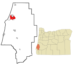
| Location in Oregon | |
| Basic data | |
| Foundation : | 1874 |
| State : | United States |
| State : | Oregon |
| County : | Coos County |
| Coordinates : | 43 ° 23 ′ N , 124 ° 14 ′ W |
| Time zone : | Pacific ( UTC − 8 / −7 ) |
| Residents : | 16.005 (as of: 2006) |
| Population density : | 584.1 inhabitants per km 2 |
| Area : | 41.3 km 2 (approx. 16 mi 2 ) of which 27.4 km 2 (approx. 11 mi 2 ) is land |
| Height : | 3.1 m |
| Postal code : | 97420 |
| Area code : | +1 (541) 269 |
| FIPS : | 41-15250 |
| GNIS ID : | 1166633 |
| Website : | www.coosbay.org |
| Mayor : | Jeff McKeown |
Coos Bay is a port city founded in 1874 in southwest Oregon in the Pacific Northwest of the United States . In Coos Bay, the Coos River flows into the Pacific Ocean at Coos Bay .
Location and traffic
The place in Coos County with 15,620 inhabitants (2002 census) on an area of 41.3 km² is a popular tourist destination mainly because of its sandy beach with extensive dunes . Much of the dune area is part of the Oregon Dunes National Recreation Area , a National Recreation Area (" Recreation Area of National Importance") under the direction of the US Forest Service . Oregon State Road OR 540 , the Cape Arago Highway , leads from North Bend to the north for 22 km along the coast to the three state parks Sunset Bay , Shore Acres and Cape Arago .
Attractions
The National Park Service lists 21 structures and sites in the National Register of Historic Places (NRHP) for Coos Bay (as of January 5, 2019), including the Egyptian Theater .
economy
The small town has a seaport (Port of Coos Bay) in the east - in the Upper Bay of Coos Bay - which was important for timber handling. The Canadian energy and pipeline operator Veresen is currently planning a large liquefied natural gas terminal for natural gas from the Rocky Mountains in the Jordan Cove district of Coos Bay , which is to be shipped from here to Asia. The environmental permits for this were issued in September 2015; the first gas should flow in 2019. The project, which is said to have a volume of 7 billion dollars, is criticized by environmentalists who do not consider the high greenhouse gas emissions and other expected environmental damage to be justified in view of only 150 new permanent jobs to be created.
Town twinning
Since February 10, 1983 there has been a twinning with Chōshi in Japan .
sons and daughters of the town
- Steve Prefontaine (1951–1975), middle distance runner
- Lauren Newton (* 1952), singer, composer and university lecturer
- Rich Fellers (* 1959), show jumper
Individual evidence
- ↑ City of Coos Bay - Demographics (PDF)
- ↑ USDA United States Department of Agriculture Forest Service (Engl.)
- ^ Cape Arago Highway. Retrieved August 23, 2011 .
- ↑ Search mask database in the National Register Information System. National Park Service , accessed January 5, 2019.
- ↑ http://theworldlink.com/news/local/govt-and-politics/a-peek-into-coos-county-s-economic-future/article_af9973fe-d47b-11e3-ae49-001a4bcf887a.html
- ↑ http://registerguard.com/rg/news/local/33562111-75/coos-bays-jordan-cove-liquefied-natural-gas-port-and-pipeline-gain-final-environmental-approval.html.csp ( Page no longer available , search in web archives ) Info: The link was automatically marked as defective. Please check the link according to the instructions and then remove this notice.
- ↑ http://www.willamettelive.com/2015/news/oregon-senator-environmentalists-clash-over-coos-bay-terminal/
Web links
- Port of Coos Bay (Engl.)
- Oregon's Bay Area (Engl.)
