
Cser
| Cser | |||||
|
|||||
| Basic data | |||||
|---|---|---|---|---|---|
| State : | Hungary | ||||
| Region : | Western Transdanubia | ||||
| County : | Győr-Moson-Sopron | ||||
| Small area until December 31, 2012 : | Sopron-Fertőd | ||||
| District since 1.1.2013 : | Sopron | ||||
| Coordinates : | 47 ° 25 ' N , 16 ° 56' E | ||||
| Area : | 2.93 km² | ||||
| Residents : | 30 (Jan. 1, 2011) | ||||
| Population density : | 10 inhabitants per km² | ||||
| Telephone code : | (+36) 99 | ||||
| Postal code : | 9375 | ||||
| KSH kódja: | 30191 | ||||
| Structure and administration (as of 2019) | |||||
| Community type : | local community | ||||
| Mayor : | István Várallay (independent) | ||||
| Postal address : | Fő utca 44 9375 Csér |
||||
| Website : | |||||
| (Source: A Magyar Köztársaság helységnévkönyve 2011. január 1st at Központi statisztikai hivatal ) | |||||


Csér is a Hungarian municipality in Sopron County in Győr-Moson-Sopron County . In terms of population, it is the smallest municipality in the district.
Geographical location
Csér is a good six kilometers west of the city of Répcelak . The neighboring municipality of Csáfordjánosfa is one kilometer east of the village.
Attractions
- Bell Tower (Harangláb)
- Seven lakes, north of the municipality

Main Street ( Fő utca )

Main street with a view of the bell tower
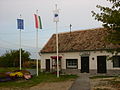
General store
_F%C5%91_utca.JPG)


traffic
Csér can only be reached via the secondary road no. 86101. The nearest train stations are in Répcelak and to the south in Vasegerszeg . There are bus connections to Csáfordjánosfa, Csapod, Ebergőc , Iván, Kapuvár , Sopron and Újkér.
Web links
- Official website ( Hungarian )
- Csér at tourinform (Hungarian)
- Csér bei Éledő falvak (Hungarian)