Zsira
| Zsira | ||||
|
||||
| Basic data | ||||
|---|---|---|---|---|
| State : | Hungary | |||
| Region : | Western Transdanubia | |||
| County : | Győr-Moson-Sopron | |||
| Small area until December 31, 2012 : | Sopron-Fertőd | |||
| Coordinates : | 47 ° 27 ' N , 16 ° 41' E | |||
| Height : | 195 m | |||
| Area : | 14.73 km² | |||
| Residents : | 744 (Jan. 1, 2011) | |||
| Population density : | 51 inhabitants per km² | |||
| Telephone code : | (+36) 99 | |||
| Postal code : | 9476 | |||
| KSH kódja: | 04622 | |||
| Structure and administration (as of 2015) | ||||
| Community type : | local community | |||
| Structure : | Zsira, Gyüleviz, Salamonfa | |||
| Mayor : | Ferdinánd Nagy (independent) | |||
| Postal address : | Rákóczi utca 8 9476 Zsira |
|||
| Website : | ||||
| (Source: A Magyar Köztársaság helységnévkönyve 2011. január 1st at Központi statisztikai hivatal ) | ||||
Zsira (German Tening , Croatian rarely Žira ) is a municipality in the western Hungarian region of Western Transdanubia in Győr-Moson-Sopron County in Hungary . It is located near the border with Austria on the Rabnitz , a road connects the village with the Austrian municipality of Lutzmannsburg to the west .
history
The place was first mentioned in 1225 as Syra , the incorporated villages Salamonfa in 1412 and Gyüleviz in 1466. Until 1848 Zsira was owned by the bishops of Raab and was part of the Ödenburg County in the Kingdom of Hungary . After the end of the First World War , the village was to be attached to the Austrian Burgenland , but there was an exchange of territory and so Zsira became part of Hungary in 1922. In 1931 today's community was founded by incorporating the previously independent villages Gyüleviz (Jelewies) and Salamonfa (Salmasdorf) in the east .
Attractions
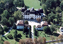
- Rimanóczy baroque castle
- Church of St. Joseph in Solomonfa
- Church of St. Lawrence
Web links
- Overview of the history of the site ( Memento from January 31, 2009 in the Internet Archive )


