Cwm (Denbighshire)
|
Cwm Welsh Cwm |
||
|---|---|---|
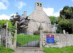
| The Church of SS Mael and Sulien in Cwm | ||
| Coordinates | 53 ° 17 ′ N , 3 ° 24 ′ W | |
| OS National Grid | SJ 06296 77390 | |
|
|
||
| Residents | 378 (as of: 2011 census) | |
| surface | 15.009 km² (5.8 mi² ) | |
| Population density: | 25 inhabitants per km² | |
| administration | ||
| Post town | RHYL | |
| ZIP code section | LL18 | |
| Part of the country | Wales | |
| Preserved County | Flintshire | |
| Unitary authority | Denbighshire | |
| ONS code | W04000148 | |
| British Parliament | Vale of Clwyd | |
| Welsh Parliament | Vale of Clwyd | |
Cwm ( ) is a place and community in the Welsh Principal Area Denbighshire near the coast of the Irish Sea . According to the 2011 census, the community had 378 inhabitants.
geography
The community of Cwm is in the north of Denbighshire south of the seaside resort Prestatyn and northeast of St Asaph . The A55 road runs in the south of the community . In the community area is the 302 meter high mountain Mynydd y Cwm and the 238 meter high mountain Marian Ffrith . In addition to the main town of Cwm, there are several other settlements such as Marian Cwm . The main town is about 101.1 meters above sea level.
The community is on the border between Denbighshire and Flintshire . In the north it borders on both the Dyserth community, which belongs to the former, and the Trelawnnyd and Gwaenysgor community, which belongs to the latter , in the east on the Whitford community which belongs to Flintshire , to the south on the Denbighshire communities Tremeirchion and Waen and in the west Rhuddlan .
history
Cwm is described in the book Imperial Gazetteer of England and Wales published in the early 1870s , where the name Combe is mentioned as an alternative name .
Population development
| year | 1801 | 1811 | 1821 | 1831 | 1841 | 1851 | 1861 | 1871 | 1881 | 1891 | 1901 | 1911 | 1921 | 1931 | 1941 | 1951 | 1961 | 1971 | 1981 | 1991 | 2001 | 2011 |
|---|---|---|---|---|---|---|---|---|---|---|---|---|---|---|---|---|---|---|---|---|---|---|
| Residents | 415 | 384 | 383 | 442 | 527 | 558 | ? | ? | 418 | 350 | 346 | 362 | 394 | 358 | ? | 316 | 348 | ? | ? | ? | ? | 378 |
Transport and infrastructure
Several major roads lead through the community, including the A55 road from Chester to Holyhead . Cwm also has a bus line that runs between Denbigh and Cwm itself. In addition, the Rhedyn Coch Farm Airstrip is a small airport on the community's territory.
Buildings
There are a total of 19 buildings on the Statutory List of Buildings of Special Architectural or Historic Interest in the community area. A majority of thirteen buildings are Grade II buildings ( e.g. the 17th century Marian Mawr farmhouse ), the remaining buildings, e.g. the Church of SS Mael and Sulien or several farmhouses, are Grade II * buildings .
Personalities
- Dafydd Ddu o Hiraddug († 1370), Welsh scholar and poet, was buried near Cwm
Web links
Individual evidence
- ↑ a b c d e f g Cwm Parish - Local Area Report. In: nomisweb.co.uk. University of Durham , accessed May 31, 2020 .
- ↑ a b Election Maps. Ordnance Survey, accessed on May 16, 2020 (English, To get to Community Cwm: Please check the Parishes tab in the Parishes section in front of Civil Parishes or Communities and then enter "Cwm Denbighshire" in the search field on the right).
- ^ Cwm, Denbighshire (Sir Ddinbych). In: getoutside.ordnancesurvey.co.uk. Ordnance Survey , accessed May 31, 2020 .
- ^ History of Cwm. In: A Vison of Britian through time. University of Portsmouth and others, accessed May 31, 2020 .
- ↑ Cwm CP / AP through time. In: A Vison of Britian through time. University of Portsmouth and others, accessed May 31, 2020 .
- ^ Cwm Crossroads. bustimes.org, accessed May 31, 2020 .
- ↑ Rhedyn Coch Farm Airstrip Airport. AirportGuide, accessed on May 31, 2020 (English).
- ↑ a b Listed Buildings in Cwm, Denbighshire. British Listed Buildings, accessed May 31, 2020 .
- ↑ Marian Mawr. In: coflein.gov.uk. Royal Commission on the Ancient and Historical Monuments of Wales, accessed May 31, 2020 .
- ^ Cwm Parish Church. In: www.clwydfhs.org.uk. Clwyd Family History Society, 2012, accessed May 31, 2020 .
- ^ St Mael & St Sulien. Explore Churches, accessed May 31, 2020 .

