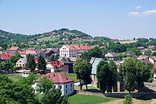
Czchów
| Czchów | ||
|---|---|---|

|
|
|
| Basic data | ||
| State : | Poland | |
| Voivodeship : | Lesser Poland | |
| Powiat : | Brzeski | |
| Gmina : | Czchów | |
| Area : | 14.08 km² | |
| Geographic location : | 49 ° 50 ′ N , 20 ° 41 ′ E | |
| Residents : | 2375 (December 31, 2016) | |
| Postal code : | 32-860 | |
| Telephone code : | (+48) 14 | |
| License plate : | KBR | |
| Economy and Transport | ||
| Next international airport : | Krakow-Balice | |
Czchów is a city in Poland in the Lesser Poland Voivodeship . It is the seat of the town-and-country municipality of the same name with a little over 9800 inhabitants.
Geographical location
The city is located in the south of Poland, on the eastern edge of Pogórze Wiśnickie , about 50 kilometers north of the Slovakian border. The Dunajec River runs about a kilometer east of the city center .
history
The oldest written mention of Schov is dated between 1208 and 1218. In the second half of the 13th century a castle was built on Dunajec. The first mention of a church in Czechow comes from the year 1325. When exactly the place received the city charter for the first time is not certain, at least a bailiff of Czchów (Wojsław) was mentioned in 1333, which was the first indication of the city charter. In 1355 Casimir the Great confirmed the town charter and extended it to Magdeburg law . In 1357 the city was named as Czchow alio modo Alba Ecclesia , also after the new dominant white Gothic church. In the late 14th century, the first names of the townspeople appeared, including of German origin, as well as the German surname Wyskirche (1372), Wizkirche (1375), used for the last time by Jan Długosz in the years 1470 to 1480 ( Woyskyerche id est Alba Ecclesia ) . In the late 14th and early 15th centuries, the castle was also expanded as the seat of the Starosts .
A sewage system was set up in 1545 and was to remain in operation until May 1987. During the first partition of Poland in 1772, Czchów came under Austrian rule.
After the First World War , the city lost its town charter in 1928. At the end of the Second World War , the Red Army marched into the city in January 1945 . Between 1954 and 1961 Czchów belonged to the Gromada Filipowice .
On January 1, 2000, Czchów was reassigned its town charter .
Buildings
- a Gothic church from 1346
- Ruins of a castle from the 13th / 14th centuries century
local community
The town-and-country community (gmina miejsko-wiejska) Czchów with an area of 66.47 km² includes other villages in which more than 9200 people live with the town.
traffic
State road 75 from Brzesko to Nowy Sącz runs through the town . The nearest international airport is John Paul II Airport in Kraków-Balice , which is about 60 kilometers west of Czchów.
sons and daughters of the town
- Stanisław Milski (1897–1972), actor and director.
Web links
- City website (multilingual)
Individual evidence
- ↑ a b c Tomasz Jurek (editor): CZCHÓW ( pl ) In: Słownik Historyczno-Geograficzny Ziem Polskich w Średniowieczu. Edycja elektroniczna . PAN . 2010-2016. Retrieved April 22, 2019.
- ↑ Ordinance No. 19 / IV / 54 Wojewódzkiej Rady Narodowej w Krakowie z dnia 6 października 1954 r. on the division of the Gromadas in the Powiat Brzeski (Brzesko) (Dziennik Urzędowy Wojewódzkiej Rady Narodowej w Krakowie z dnia 29 listopada 1954 r., No. 11, Poz. 50)


