
Czernina (Góra)
| Czernina | |||
|---|---|---|---|

|
|
||
| Basic data | |||
| State : | Poland | ||
| Voivodeship : | Lower Silesia | ||
| Powiat : | Góra | ||
| Gmina : | Góra | ||
| Geographic location : | 51 ° 43 ' N , 16 ° 37' E | ||
| Residents : | 816 (2011) | ||
| Telephone code : | (+48) 65 | ||
| License plate : | DGR | ||

Czernina (German Tschirnau , 1937-1945: Lesten ) is a former town, today's village in the municipality of Góra ( Guhrau ) in the powiat Górowski ( Guhrauer Kreis ) of the Polish Voivodeship of Lower Silesia . In 2011 the village had 816 inhabitants.
Geographical location
The village is located in Lower Silesia , about nine kilometers northeast of the city of Guhrau ( Góra ). In the immediate vicinity is the village of Czernina Dolna (German Nieder Tschirnau , 1937-1945: Nieder Lesten ) and in the east the village of Czernina Górna (German Ober Tschirnau , 1937-1945: Ober Lesten ).
history
The village was first mentioned in 1284 and received town charter in 1584.
At the beginning of the 20th century, the city had a Protestant church, a Catholic church and a noble fräuleinstift.


Until 1945 Lesten belonged to the district of Guhrau in the administrative district of Breslau in the Prussian province of Lower Silesia of the German Empire .
After the end of the Second World War , Lesten was placed under Polish administration by the Soviet occupying forces, along with almost all of Silesia . The Poles introduced the Polish place name Czernina for Lesten . The village lost its town charter. As far as the residents had not fled, most of them were subsequently evicted by the local Polish administrative authorities .
Population development until 1945
| year | Residents | Remarks |
|---|---|---|
| 1803 | 802 | |
| 1810 | 880 | |
| 1816 | 895 | 806 Protestants, 80 Catholics and nine Jews |
| 1821 | 764 | |
| 1825 | 635 | (in 110 houses) thereof 23 Catholics |
| 1840 | 798 | (in 103 houses) of which 722 Protestants and 76 Catholics |
| 1905 | 686 | mostly evangelicals |
| 1925 | 672 | |
| 1933 | 749 | |
| 1939 | 840 |
Attractions

Tschirnau Castle ruins (photo 2004).

Tschirnau Castle ruins (photo 2005).
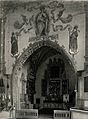
Choir and east wall of the Catholic Church (photo taken around 1912).


- Ruins of Ober-Tschirnau Castle, first mentioned in 1626, seat of the women's foundation “von Lestwitz” between 1815 and 1945 , burned out during World War II
- Catholic Church of St. Laurentius, first mentioned in 1376, today's building erected in the 15th century
- Catholic burial chapel, built in the 17th century
- Ruins of the Protestant church, built in 1742/43, destroyed except for the church tower in the Second World War
- Town hall, built in 1799/1800
literature
- in order of appearance
- Leopold Freiherr von Zedlitz-Neukirch , New Prussian Nobility Lexicon , 1836
- Johann Georg Knie : Alphabetical-statistical-topographical overview of the villages, towns, cities and other places of the royal family. Preusz. Province of Silesia . 2nd edition, Breslau 1845, pp. 941-942.
- Hugo Weczerka (Hrsg.): Handbook of the historical places . Volume: Silesia (= Kröner's pocket edition . Volume 316). Kröner, Stuttgart 1977, ISBN 3-520-31601-3 , p. 546.
Web links
- Description of the cath. St. Laurentius Church (Polish)
- Description of the cath. Church of St. Lawrence, site of the Archdiocese of Wroclaw (Polish)
Individual evidence
- ↑ a b Meyer's Large Conversation Lexicon . 6th edition, Volume 19, Leipzig and Vienna 1909, p. 779.
- ↑ a b c d Alexander August Mützell and Leopold Krug : New topographical-statistical-geographical dictionary of the Prussian state . Volume 5: T – Z , Halle 1823, pp. 394–395, item 755.
- ^ Johann Georg Knie : Alphabetical-statistical-topographical overview of the villages, spots, towns and other places of the royal family. Prussia. Province of Silesia, including the Margraviate of Upper Lusatia, which now belongs entirely to the province, and the County of Glatz; together with the attached evidence of the division of the country into the various branches of civil administration . Breslau 1830, p. 797.
- ^ Johann Georg Knie : Alphabetical-statistical-topographical overview of the villages, spots, cities and other places of the royal family. Preusz. Province of Silesia . 2nd edition, Breslau 1845, pp. 941-942.
- ^ A b c Michael Rademacher: German administrative history from the unification of the empire in 1871 to the reunification in 1990. guhrau.html # ew39guhrlesten. (Online material for the dissertation, Osnabrück 2006).