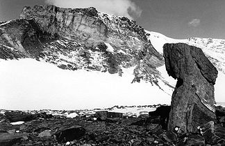
Dallmann Mountains
| Dallmann Mountains | ||
|---|---|---|
|
The main massif of the Dallmannberge seen from the northeast. |
||
| Highest peak | Mörkenatten ( 2515 m ) | |
| location | Queen Maud Land , East Antarctica | |
| part of | Orvinfjella | |
|
|
||
| Coordinates | 71 ° 48 ′ S , 10 ° 30 ′ E | |
| surface | 250 km² | |
The Dallmannberge ( Norwegian Dallmannfjellet ) consist of a group of ice-free rock massifs and Nunatakker in the East Antarctic Queen Maud Land . They rise over an area of about 250 km² as part of the Orvinfjella . The mountains were named after Eduard Dallmann , the captain of the auxiliary sailor Groenland , who explored whale and seal populations in the Antarctic from 1873 to 1874.
In January 1939, the ice-free mountain region was discovered during flights of the German Antarctic Expedition 1938/39 and documented with the help of aerial photographs . Since most of the aerial photos were lost in the Second World War, the mountains were photographed again during the Norwegian Antarctic Expedition 1956–1960 and control points on the ground were also measured for more precise orientation . The first geological research took place as part of the 4th Soviet Antarctic Expedition 1958-1960. Systematic geological mapping and exploration was continued by the GeoMaud expedition in 1995–1996 .
geography
The mountain range consists of two geomorphologically different areas. The western portion is of one to 2,486 meters high, compact massif with a wide open north Kar formed. The eastern part, separated from the main massif by a glaciated valley ( Slabotnen ), is a strongly indented mountain ridge that runs in north-south direction and is called Småskeidrista . At its southern end is the Mörkenatten, the highest elevation of the mountains with 2515 m. To the north the ridge sinks to 1590 m and only protrudes from the inland ice in the form of individual nunataks . The mountains are bounded to the west and east by wide glaciers ; the Glopeken in the west separates the Dallmann Mountains from the Conrad Mountains , in the east the Somoveken forms the border with the Alexander von Humboldt Mountains . Both glaciers unite on the northern foreland of the mountains and flow out onto the Lazarev Ice Shelf .
geology
The mountain range consists of highly metamorphic , multiply folded gneisses , amphibolites and marbles , the parent rocks of which are volcanic and sedimentary rocks of an island arc with a Mesoproterozoic age. At the turn of the Mesoproterozoic / Neoproterozoic , these rocks were deformed and metamorphically overprinted for the first time when the arch of the island collided with the Kalahari craton . The rocks underwent another deformation when the West and East Gondwana collided approx. 540 mya ago , creating today's fold structure . The mountains have been subject to erosion since the Ordovician .
literature
- Karsten Brunk: Cartographic work and German naming in Neuschwabenland, Antarctica . (pdf) In: German Geodetic Commission, Series E: History and Development of Geodesy . 24 / I, 1986, pp. 1-42. Retrieved April 19, 2009.
- Norsk Polarinstitutt (ed.): Blad L5 Humboldtfjella (topographic map 1: 250,000) . Oslo 1968.
- Hans-Jürgen Paech (Ed.): International GeoMaud Expedition of the BGR to Central Dronning Maud Land in 1995/96 . Volume I: Geological Results. Schweizerbart, Stuttgart 2004, ISBN 978-3-510-95923-5 , p. 499 .
- Alfred Ritscher : Scientific and aeronautical results of the German Antarctic Expedition 1938/39 . Koehler & Amelang, Leipzig 1942, p. 1-304 .
Web links
- Australian Antarctic Division datasheet accessed May 10, 2010
- Geographical names in the area of the GEOMAUD expedition (PDF; 215 kB) accessed on May 12, 2010
- Standing Committee on Geographical Names : Geographical Names of Antarctica , accessed October 17, 2016

