Dęblin
| Dęblin | ||
|---|---|---|

|
|
|
| Basic data | ||
| State : | Poland | |
| Voivodeship : | Lublin | |
| Powiat : | Ryki | |
| Area : | 38.51 km² | |
| Geographic location : | 51 ° 34 ' N , 21 ° 51' E | |
| Height : | 113 m npm | |
| Residents : | 16,026 (Jun. 30, 2019) |
|
| Postal code : | 08-530 | |
| Telephone code : | (+48) 81 | |
| License plate : | LRY | |
| Economy and Transport | ||
| Street : | DK 48 Kock - Kozienice | |
| Next international airport : | Warsaw | |
| Gmina | ||
| Gminatype: | Borough | |
| Residents: | 16,026 (Jun. 30, 2019) |
|
| Community number ( GUS ): | 0616011 | |
| Administration (as of 2016) | ||
| Mayoress : | Beata Siedlecka | |
| Address: | Rynek 12 08-530 Dęblin |
|
| Website : | www.deblin.pl | |
Dęblin [ ˈdɛmblʲin ] ( German Demblin ) is a city in Poland in the Lublin Voivodeship . It was known as Ivangorod under Russian rule in the 19th and early 20th centuries . The present center of the city was at the point of a grange of Dęblin 1854, was established in the district or independent place called Irena .
history
The first documented mention of today's Dęblin comes from June 14, 1397 when the former village was sold for 200 grzywna praska . In the 15th century the settlement belonged to the Tarło family of the Topór family . From the end of the 16th century to the 19th century, interrupted only for about half a century, the Mniszech family was owned by Dęblin.
During the Third Partition of Poland , the place came under Prussian rule. With the formation of the Duchy of Warsaw , Dęblin became part of the same and in 1815 part of the newly formed Congress Poland .
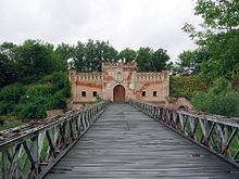
In 1836 the property previously owned by Polish nobles was sold to the Russian-ruled Polish state. In 1838 the construction of a fortress began to secure a passage over the Vistula. 1840 the village was then after the then governor of Poland Ivan Paskevich in Ivangorod renamed. Today's center of the city, the district of Irena , was created on June 2, 1854 on the site of the Dęblin suburb . The Ivangorod Fortress was one of the strongest fortresses of the Russian Empire. In 1876 it was connected to the rail network.
During the First World War , after the Russian army had withdrawn, the place was first occupied by the Austrian and then by the German army. During this time the place got its original name Dęblin back. At the same time, however , Irena retained his independence.
In April 1927, Dęblin became the seat of the officers' flight school in which 266 pilots, among others, were trained in the interwar period . The Dęblin military airfield is still an air force training facility.
On September 15, 1939, the place was occupied during the attack on Poland by the Wehrmacht . During the occupation, the Stalag 307 prisoner-of-war camp was operated in Dęblin from 1941 to 1943 , and the Oflag 77 officer camp from 1943 to 1944 . A Jewish ghetto was set up in the Irena area in mid-1940 , which was dissolved on October 14, 1942. On 25/26 July 1944 the Red Army marched into the city. In 1953 the name Dęblin was introduced for the municipality of Irena . The city charter Dęblin received on 13 November 1954th
coat of arms
The city received the coat of arms on March 2nd, 1993. It shows a silver eagle with a golden ball in its claws from which four golden lightning bolts emerge.
Buildings
- Palace complex, built at the end of the 18th to the beginning of the 20th century
- Fortifications built in the mid to late 19th century
- Parish Church of Christian Mercy ( Kościół Parafialny Pod Wezwaniem Chrystusa Miłosiernego ) from the 18th century
- Fallen cemetery of the Second World War in Balonna Street
traffic
Through the city for the national road 48 from Kock to Tomaszów Mazowiecki . Furthermore, the voivodship road 801 ( droga wojewódzka 801 ) runs through the city from Puławy, 18 kilometers south, to Warsaw, about 80 kilometers north .
The nearest international airport is Warsaw Frédéric Chopin Airport, about 90 kilometers northwest of Dęblin. The city itself has a small airfield , which is located in the southeast of Deblin.
Web links
- City website (Polish, English, Italian)
- Detailed page about the city (Polish)
- Collection of pictures about Dęblin
Individual evidence
- ↑ a b population. Size and Structure by Territorial Division. As of June 30, 2019. Główny Urząd Statystyczny (GUS) (PDF files; 0.99 MiB), accessed December 24, 2019 .
- ↑ mapa.szukacz.pl ( page no longer available , search in web archives ) Info: The link was automatically marked as defective. Please check the link according to the instructions and then remove this notice.
- ↑ Archive link ( Memento of the original from May 23, 2008 in the Internet Archive ) Info: The archive link was automatically inserted and not yet checked. Please check the original and archive link according to the instructions and then remove this notice.


