Delson (Quebec)
| Delson | ||
|---|---|---|
| Location in Quebec | ||
|
|
||
| State : |
|
|
| Province : | Quebec | |
| Administrative region : | Montérégie | |
| MRC or equivalent : | Roussillon | |
| Coordinates : | 45 ° 23 ′ N , 73 ° 33 ′ W | |
| Height : | 12 m | |
| Area : | 7.76 km² | |
| Residents : | 7462 (as of 2011) | |
| Population density : | 961.6 inhabitants / km² | |
| Time zone : | Eastern Time ( UTC − 5 ) | |
| Municipality number: | 67025 | |
| Postal code : | J5B | |
| Area code : | +1 450 | |
| Mayor : | Gilles Meloche | |
| Website : | www.ville.delson.qc.ca | |
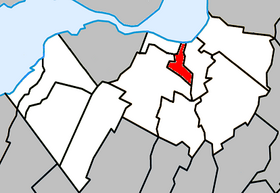
 Location in the MRC Roussillon |
||
Delson is a city in the southwest of the Canadian province of Québec . It is located in the administrative region of Montérégie , about 15 km south of central Montreal . Delson belongs to the regional county municipality (municipalité régionale du comté) Roussillon , has an area of 7.76 km² and has 7,462 inhabitants (2011).
geography
Delson is located in the Rive-Sud region on the southern bank of the Saint Lawrence River and is part of the Communauté métropolitaine de Montréal . A section of the Sankt-Lorenz-Seeweg is located in the municipality . The Rivière de la Tortue, a strongly meandering stream that flows into the stream, flows from south to north. Neighboring municipalities are Candiac in the east, Saint-Constant in the west and Sainte-Catherine in the northwest.
history
The first French settlers settled on the banks of the Rivière de la Tortue in the second half of the 17th century and farmed there. The area developed slowly at first, until three different railway companies each built a line in the first decade of the 20th century. In 1911 a brick factory was built , after which the settlement increased significantly. In 1912 a post office was opened at the station, which was named Delson - derived from the Delaware and Hudson Railway, which operates here . The name carried over to the place, which in 1918 became an independent municipality (the municipality previously belonged to Saint-Constant) and received city status in 1957.
Transport and economy
Two motorways intersect southeast of Delson: Autoroute 15 leads from Montreal to the border of the US state of New York , while Autoroute 30 extensively bypasses the Montreal agglomeration. An important major road link is Route 132 towards Salaberry-de-Valleyfield . Delson owns a train station on a suburban railway line of the Agence métropolitaine de transport , which leads to Lucien-L'Allier train station in downtown Montreal. The bus company CIT Roussillon operates several lines to the neighboring communities and to Montreal.
Delson is the location of an industrial park . In addition, part of the railway museum Musée ferroviaire canadien is located in the municipality.
population
According to the 2011 census, Delson had 7,462 inhabitants, which corresponds to a population density of 961.6 inh / km². 87.1% of the population stated French as their main language, while English accounted for 5.6%. 1.0% said they were bilingual (French and English), 6.3% other languages and multiple answers. Only French spoke 50.4%. In 2001, 93.0% of the population were Roman Catholic , 4.1% Protestant, and 2.5% of no denomination.
Web links
Individual evidence
- ^ Delson. Commission de toponymie du Québec, accessed December 9, 2013 (French).
- ^ Population profile of the parish of Delson. In: 2011 Census. Statistics Canada , 2011, accessed December 10, 2013 (French).
- ^ Population profile of the parish of Delson. In: 2001 Census. Statistics Canada , 2001, accessed December 10, 2013 (French).

