Santa Bárbara Department (Honduras)
| Santa Bárbara | |
|---|---|
| Location of Santa Bárbara in Honduras | |
| Data | |
| Capital | Santa Bárbara |
| population | 341,000 (2006 calculation) |
| surface | 5115 km² |
| Population density | 67 inhabitants / km² |
| structure | 28 |
| ISO 3166-2 | HN-SB |
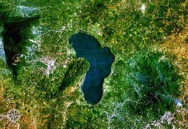
| Satellite image of Lake Yojoa | |
Santa Bárbara is one of 18 departments in Honduras in Central America and is located in the northwest of the country on the border with Guatemala .
The capital of the department is the city of the same name, Santa Bárbara. Santa Bárbara borders the largest inland lake in Honduras - Lago de Yojoa .
Municipios
Administratively, the Department of Santa Bárbara is in turn divided into 28 municipalities :
| Arada | Atima |
| Azacualpa | Ceguaca |
| Chinda | Concepción del Norte |
| Concepción del Sur | El Nispero |
| Gualala | Ilama |
| Las Vegas | Macuelizo |
| Naranjito | Nueva Frontera |
| Nuevo Celilac | Petoa |
| Protección | Quimistán |
| San Francisco de Ojuera | San Jose de Colinas |
| San Luis | San Marcos |
| San Nicolás | San Pedro Zacapa |
| Santa Bárbara | Santa Rita |
| San Vicente Centenario | Trinidad |
Web links
Coordinates: 15 ° 0 ′ N , 88 ° 30 ′ W


