
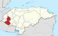
Lempira Department
| Lempira | |
|---|---|
  |
|
| Data | |
| Capital | Gracias |
| population | 269,000 (2006 calculation) |
| surface | 4290 km² |
| Population density | 63 people / km² |
| structure | 28 |
| Highest elevation | Cerro de Las Minas (2849 m above sea level ) |
| ISO 3166-2 | HN-LE |
Lempira is one of 18 departments in Honduras in Central America .
The department is located in the west of the country on the border with El Salvador . The capital of Lempira is Gracias . The department is named after a local Maya warrior ( Lenca-Maya ) named Lempira, who fought against the Spanish conquistadors in the 16th century . Lempira is also the name of today's Honduran currency .
In Lempira, in addition to the Celaque National Park, there is also Cerro Las Minas - the highest mountain in Honduras at 2849 meters.
Municípios
Administratively, the Lempira Department is in turn divided into 28 municipalities :
| 1 Belén | 2 candelaria |
| 3 Cololaca | 4 Erandique |
| 5 Gracias | 6 Gualcince |
| 7 guarita | 8 La Campa |
| 9 La Iguala | 10 Las Flores |
| 11 La Unión | 12 La Virtud |
| 13 Lepaera | 14 Mapulaca |
| 15 Piraera | 16 San Andrés |
| 17 San Francisco | 18 San Juan Guarita |
| 19 San Manuel Colohete | 20 San Marcos de Caiquín |
| 21 San Rafael | 22 San Sebastian |
| 23 Santa Cruz | 24 Talgua |
| 25 tambla | 26 Tomalá |
| 27 Valladolid | 28 Virginia |
Web links
Atlántida | Choluteca | Colón | Comayagua | Copán | Cortés | El Paraíso | Francisco Morazan | Gracias a Dios | Intibucá | Islas de la Bahía | La Paz | Lempira | Ocotepeque | Olancho | Santa Bárbara | Valle | Yoro
Coordinates: 14 ° 30 ′ N , 88 ° 36 ′ W