
Dickibach
| Dickibach | ||
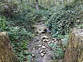
 Waterfall on the Dickibach at the beginning of the Tatschtobel |
||
| Data | ||
| Water code | CH : ZH101327 | |
| location |
Switzerland
|
|
| River system | Rhine | |
| Drain over | Hüenerbach → Kempt → Töss → Rhine → North Sea | |
| source | a little south of the hamlet of First 47 ° 25 ′ 53 ″ N , 8 ° 44 ′ 4 ″ E |
|
| Source height | 639 m above sea level M. | |
| muzzle | in Giessentobel in the Hüenerbach Coordinates: 47 ° 25 ′ 1 ″ N , 8 ° 43 ′ 39 ″ E ; CH1903: 697 271 / 252 581 47 ° 25 '1 " N , 8 ° 43' 39" O |
|
| Mouth height | 519 m above sea level M. | |
| Height difference | 120 m | |
| Bottom slope | 57 ‰ | |
| length | 2.1 km | |
| Catchment area | 77 ha | |
| Left tributaries | Geissacherbach | |
| Right tributaries | Talmattbächli, Seewadelgraben | |
 The Dickibach above the Tatschtobel |
||
The Dickibach is a 2.1 kilometer long right tributary of the Hüenerbach in the Swiss canton of Zurich . The stream drains a section of the Kempttal region in the Zürcher Oberland and flows through the Tatschtobel .
The Federal Office for the Environment characterizes the Dickibach as a steep, small river of the colline, carbonate central plateau.
geography
course
The Dickibach rises on the Galgenweg at 639 m above sea level. M. just within the grove of Galgen , which borders on the agriculturally used Widenriet . The source is located a little south of and below the hamlet of First ( 683 m above sea level ) and a little northwest of Agasul ( 598 m above sea level ).
The stream crosses directly under the Galgenweg and runs only slightly deepened down the gentle slope. It flows to the south-southwest through the southern part of the gallows before it meets the Wolfacherstrasse , which marks the edge of the forest here. It is overturned and directed to the south-east, passing under the eastern part of the Wolfacher field . Shortly afterwards he picks up the Geissacherbach, which is also overturned, from the left. From here it is directed briefly to the south-southwest, then to the southeast under the Chüenzler corridor . In this case, it drains a part of the Wolf Achers by a seepage pipe and a small section of the corridor Chüenzler . It follows the Eichhalderweg , before it reaches 601 m above sea level. M. in a field on the western side of the small elevation Burgbüel ( 612 m above sea level ) comes to the surface for the first time.

The Dickibach now flows back to the south-southeast, following the forest of Oberholz on the right bank, which begins behind a path on the right bank. It flows through the Gilzen corridor , in which it was completely exposed again around 2017. Only the agriculturally used Burgbüelweg is crossed in a pipe. After crossing under Luckhauserstrasse at the confluence of the Oberholzweg and Tobelacherweg, it follows the latter path. This is followed by the creek on the western border of the Tobelacher Flur for around 105 meters to the southeast, before it is overturned again and directed to the southwest. At the same time, it crosses under the Tobelacherweg and then the Talmatt corridor , taking up a short drainage line from the left. After crossing under the Talmattweg , it reaches the Lattenholz forest near Hof Schömlet , where the dole ends. At the same time, an about 30 meters long, nameless tributary flows into the Dickibach from the left, which drains a small area in the southernmost section of the Talmatt through a drainage pipe .
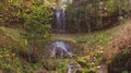
The stream flows to the southwest, making a small curve to the southeast. This is followed by the confluence of the Talmattbächlis from the right as well as the crossing under the Lattenholzweg . Immediately afterwards it forms a small ravine in which it has dug itself into the Upper Freshwater Molasse. This is followed on the left bank by the Weidweg and on the right bank by the Dickibachweg until a little below the crossing under the Heizibüel path through the Dickibach. It turns briefly to the south-west and then to the south-south-west, with the 40-meter-long Seewadelgraben flowing into it from the right, which is fed by a longer seepage pipe from the Latten area . At the same time, on the right bank, about 70 meters away, it passes the Im Tatsch area with a former quarry. Another 60 meters is followed by a 5 meter high waterfall, which falls into the Tatschtobel . This is made accessible by the Tobelweg , which has been developed as a hiking trail and follows the course of the stream from here.
It crosses the gorges and a distance of approximately 250 meters the output of the casting ravine , where he at the same time the Tobelweg at the junction with the Tätschtobelweg crosses under. The Dickibach now flows for the last 50 meters mainly to the southwest, where it meets the Hüenerbachweg , which the stream briefly follows. Finally the Dickibach flows out at 519 m above sea level. M. on the north slope of the Schüsselberg (up to 578 m above sea level ) from the right and east into the lower reaches of the Hüenerbach coming from the Giessentobel.
Catchment area
The 0.77 square kilometer catchment area extends completely over the municipality of Illnau-Effretikon . It consists of 54.3% agricultural area, 39.4% wooded area and 6.3% settlement area. The highest point is 680 m above sea level. M. at the farm Tatscherain in the hamlet of First , the average altitude is 601 m above sea level. M. The Dick Ibach by flows from Lättenholz to its mouth, the geomorphological Geological inventory of the canton of Zurich registered object casting Tobel .
The catchment area of the Chrattenbach and Eichbach , which flows into the Kempt, borders in the west, and that of the Brandrütibach , a tributary of the Töss , in the north .
Tributaries
The direct and indirect tributaries downstream
- Geissacherbach ( left ), 0.16 km
- Talmattbächli ( right ), 0.17 km
- Seewadelgraben ( left ), 0.04 km
history
The Flur Widenriet (Weidenriet) was still a reed area until the end of the Second World War . Since the overall melioration of Wildberg , the area has been drained by an underground drainage pipe that begins above the Widenrietweg and is introduced at the source of the Dickibach.
flora
On the upper reaches in the forest of Galgen , the stream flows through woodruff - beech forest with forest zest and in the picket wood , maple - ash forest with bingelwort and woodruff beech forest with lungwort line the banks of the stream. The Tatschtobel, on the other hand, is covered with sedge- Bacheschenwald with giant horsetail and typical lungwort-beech forest. At the mouth of the creek in Giessentobel , maple-ash forest also grows with ringelkweed. The forests adjacent to the Dickibach are all privately owned and are located in the Winterthur forest district and the surrounding area . According to the forest development plan of the canton of Zurich from 2010, most of it is intended for wood production.
A common neophyte along the Dickibach is the Canadian goldenrod . Others are the glandular balsam and the giant hogweed .
photos

Dickibach in the Tatschtobel
Dickibach at the beginning of the Giessentobel
Waterfall in the Tatschtobel


Web links
- Course of the Dickibach on GIS Zurich
- Course of the Dickibach on the geoserver of the Swiss federal administration
Individual evidence
- ↑ a b c d Geographic information system of the Canton of Zurich
- ↑ a b Geoserver of the Swiss Federal Administration ( information )
- ↑ a b Modeled mean annual discharge. In: Topographical catchment areas of Swiss waters: sub-catchment areas 2 km². Retrieved September 1, 2017 .
- ↑ Lengths rounded to two decimal places