Cajamarca district
| Cajamarca district | |||
|---|---|---|---|
 The district of Cajamarca is located in the northwest of the province of Cajamarca (marked in red) |
|||
| Symbols | |||
|
|||
| Basic data | |||
| Country | Peru | ||
| region | Cajamarca | ||
| province | Cajamarca | ||
| Seat | Cajamarca | ||
| surface | 382.7 km² | ||
| Residents | 218,741 (2017) | ||
| density | 572 inhabitants per km² | ||
| ISO 3166-2 | PE-CAJ | ||
| Website | www.municaj.gob.pe (Spanish) | ||
| politics | |||
| Alcalde Provincial | Víctor Andrés Villar Narro (2019-2022) |
||
| Political party | Frente Regional de Cajamarca | ||
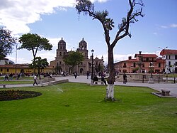
| Plaza de Armas in Cajamarca | |||
Coordinates: 7 ° 10 ′ S , 78 ° 30 ′ W
The district of Cajamarca is located in the province of Cajamarca in the region of Cajamarca in northwestern Peru . The district has an area of 382.74 km². The 2017 census counted 218,741 inhabitants. In 1993 the population was 117,509, in 2007 188,363. The seat of the district, provincial and regional administration is located at an altitude of 2750 m in the city of Cajamarca with 182,971 inhabitants (as of 2017). Cajamarca is located in the southeast of the district. The Yanacocha mine in the northeast of the district is open-cast gold.
Geographical location
The district of Cajamarca is located in the Andean highlands east of the Peruvian western cordillera in the northwest of the province of Cajamarca. The river Río Cajamarca drains the area in a south-easterly direction.
The district of Cajamarca borders in the northeast with the district La Encañada , in the east with the district Los Baños del Inca , in the southeast with the districts Llacanora and Jesús , in the south with the district San Juan , in the southwest with the districts Magdalena and Chetilla and in the northwest to the districts of San Pablo and Tumbaden (both in the province of San Pablo ).
Individual evidence
- ↑ a b PERU: Cajamarca region - provinces and districts . www.citypopulation.de. Retrieved March 18, 2020.


