Camaná district
| Camaná district | |
|---|---|
 The Camaná district is centrally located on the coast of the Camaná province |
|
| Basic data | |
| Country | Peru |
| region | Arequipa |
| province | Camaná |
| Seat | Camaná |
| surface | 11.1 km² |
| Residents | 13,367 (2017) |
| density | 1204 inhabitants per km² |
| ISO 3166-2 | PE-ARE |
| Website | municamana.gob.pe (Spanish) |
| politics | |
| Alcalde Provincial | Marcelo Alejandro Valdivia Bravo (2019-2022) |
| Political party | Alianza para el Progreso |
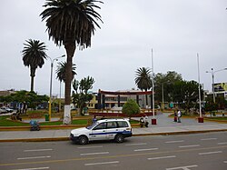
| Plaza de Armas in Camaná | |
Coordinates: 16 ° 37 ′ 28 ″ S , 72 ° 42 ′ 41 ″ W
The Camaná District is located in the Camaná Province in the Arequipa region in southwestern Peru . The district has an area of 11.1 km². The 2017 census counted 13,367 residents. In 1993 the population was 14,093, in 2007 14,758. The district administration is located in the provincial capital Camaná, 12 m high and 2.5 km from the sea . In addition to the city of Camaná, there are two smaller towns in the district.
Geographical location
The Camaná district is located in the valley of the Río Camaná, which runs 4 km to the west, in the center of the Camaná province. The district has a coastline of almost 3 km on the Pacific Ocean and extends 4 km inland. The district area is heavily populated. The unpopulated areas are used for irrigated agriculture.
The Camaná district borders on the Mariscal Cáceres district in the west, the José María Quimper district in the northwest and the Samuel Pastor district in the northeast and east .
Individual evidence
- ↑ a b PERU: Arequipa region - provinces and districts . www.citypopulation.de. Retrieved May 2, 2020.
