Pacasmayo District
| Pacasmayo District | |||
|---|---|---|---|
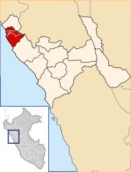
 Pacasmayo district is the second most northern on the coast of Pacasmayo Province (marked in red) |
|||
| Symbols | |||
|
|||
| Basic data | |||
| Country | Peru | ||
| region | La Libertad | ||
| province | Pacasmayo | ||
| Seat | Pacasmayo | ||
| surface | 30.8 km² | ||
| Residents | 28,959 (2017) | ||
| density | 939 inhabitants per km² | ||
| founding | November 23, 1864 | ||
| ISO 3166-2 | PE-LAL | ||
| politics | |||
| Alcalde District | César Rodolfo Milla Manay (2019-2022) |
||
| Political party | Alianza para el Progreso | ||
| Street scene in Pacasmayo | |||
Coordinates: 7 ° 24 ′ 11 " S , 79 ° 34 ′ 2" W.
The Pacasmayo District is located in the Pacasmayo Province in the La Libertad region in northwestern Peru . It has an area of 30.84 km². The 2017 census counted 28,959 inhabitants. In 1993 the population was 23,705, in 2007 it was 26,118. The district was founded on November 23, 1864. The administrative seat is the coastal town of Pacasmayo .
Geographical location
The Pacasmayo district is located on the Pacific coast 8 km south of the mouth of the Río Jequetepeque . The district has a longitudinal extension in SW-NE direction of 11.5 km. It is practically congruent with the city of the same name. The national road 1N ( Panamericana ) crosses the district. Aeropuerto de Pacasmayo Airport (ICAO: SPYO) is located south of the city of Pacasmayo . In the north the district borders on the Jequetepeque district , in the northeast on the San José and in the east and south on the district of San Pedro de Lloc .
Web links
- Municipalidad Distrital de Pacasmayo
- Peru: Region La Libertad (provinces and districts) at www.citypopulation.de
- INEI Perú


