Guadalupe District
| Guadalupe District | |||
|---|---|---|---|
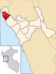
 The district of Guadalupe is located in the far north of the province of Pacasmayo (marked in red) |
|||
| Symbols | |||
|
|||
| Basic data | |||
| Country | Peru | ||
| region | La Libertad | ||
| province | Pacasmayo | ||
| Seat | Guadalupe | ||
| surface | 165.4 km² | ||
| Residents | 40,217 (2017) | ||
| density | 243 inhabitants per km² | ||
| founding | August 7, 1825 | ||
| ISO 3166-2 | PE-LAL | ||
| Website | www.muniguadalupe.gob.pe/web/ (Spanish) | ||
| politics | |||
| Alcalde District | Benjamin Javier Banda Abanto (2019-2022) |
||
| Plaza de Armas in the city of Guadalupe | |||
Coordinates: 7 ° 15 ′ S , 79 ° 28 ′ W
The Guadalupe District is located in the Pacasmayo Province in the La Libertad region in northwestern Peru . It has an area of 165.37 km². The 2017 census counted 40,217 residents. In 1993 the population was 27,002, in 2007 37,239. The district was founded on August 7, 1825. To the north of the mouth of the Río Jequetepeque is the archaeological site Pakatnamú .
Geographical location
The Guadalupe district is located on the northern bank of the Río Jequetepeque about 100 km north-northwest of the city of Trujillo . It has an approximately 5 km long section on the Pacific coast and extends up to 24 km inland. There is desert in the northwest, while irrigated agriculture is practiced along the course of the Río Jequetepeque and in the east. The administrative seat is the city of Guadalupe in the northeast of the district . The small town of Ciudad de Dios is located in the south of the district .
The district in the north of the Pacasmayo province borders on the Chepén province to the north and the San José and Jequetepeque districts to the south .
Web links
- Municipalidad Distrital de Guadalupe
- Peru: Region La Libertad (provinces and districts) at www.citypopulation.de
- INEI Perú


