Parobamba district
| Parobamba district | |
|---|---|
 The Parobamba District is located in the northeast of the Pomabamba Province (marked in red) |
|
| Basic data | |
| Country | Peru |
| region | Ancash |
| province | Pomabamba |
| Seat | Parobamba |
| surface | 339 km² |
| Residents | 6389 (2017) |
| density | 19 inhabitants per km² |
| founding | August 28, 1868 |
| ISO 3166-2 | PE-ANC |
| politics | |
| Alcalde District | Edgardo Gliden Amancio Murillo (2019-2022) |
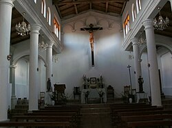
| Parobamba Church | |
Coordinates: 8 ° 42 ′ S , 77 ° 26 ′ W
The Parobamba District is located in the Pomabamba Province in the Ancash Region in western Peru . The district was founded on August 28, 1868. It has an area of 339 km². The 2017 census counted 6,389 inhabitants. In 1993 the population was 6897, in 2007 it was 6861. The district administration is located in the 3185 m high village of Parobamba (or Parobamba Alto) with 729 inhabitants (as of 2017). Parobamba is located 14 km northeast of the provincial capital Pomabamba .
Geographical location
The Parobamba District extends over the northeast of the Pomabamba Province. The Río Marañón flows along the eastern district boundary in a north-northwest direction, its tributary Río Rupac runs along the north-western district boundary to the northeast.
The district of Parobamba borders in the southwest on the district Pomabamba , in the west on the district Sicsibamba ( province Sihuas ), in the northwest on the districts Huayllabamba and Alfonso Ugarte (both also in the province Sihuas), in the northeast on the district Huancaspata ( province Pataz ) , to the east to the Huacrachuco district ( Marañón province ) and to the south to the Quinuabamba district .
Web links
- Peru: Region Ancash (provinces and districts) at www.citypopulation.de
- INEI Perú
