Pomabamba district
| Pomabamba district | |
|---|---|
 The Pomabamba District is centrally located in the Pomabamba Province (marked in red) |
|
| Basic data | |
| Country | Peru |
| region | Ancash |
| province | Pomabamba |
| Seat | Pomabamba |
| surface | 344 km² |
| Residents | 14,756 (2017) |
| density | 43 inhabitants per km² |
| founding | February 21, 1861 |
| ISO 3166-2 | PE-ANC |
| Website | munipomabamba.gob.pe (Spanish) |
| politics | |
| Alcalde Provincial | Edgard Alcídes Vía Melgarejo (2019-2022) |
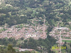
| View of Pomabamba (2008) | |
Coordinates: 8 ° 49 ′ S , 77 ° 28 ′ W
The Pomabamba District is located in the Pomabamba Province in the Ancash region in western Peru . The district was established on February 21, 1861. It has an area of 344 km². The 2017 census counted 14,756 inhabitants. In 1993 the population was 12,901, in 2007 14,933. The district administration is located in the provincial capital Pomabamba at an altitude of 2948 m with 5755 inhabitants (as of 2017).
Geographical location
The Pomabamba district is located on the eastern flank of the Cordillera Blanca in the center of the Pomabamba province. The Río Pomabamba crosses the district in a south-easterly direction. The main ridge of the Cordillera Blanca with the peaks Nevado Taulliraju, Nevado Pucahirca Central and Nevado Pucahirca Norte runs along the western district boundary.
The district of Pomabamba is bordered to the west by the districts of Santa Cruz and Yuracmara (both in the province of Huaylas ), to the northwest by the districts of San Juan and Sicsibamba (both in the province of Sihuas ), to the northeast by the districts of Parobamba and Quinuabamba , to the southeast the districts of Fidel Olivas Escudero and Casca (both in the province of Mariscal Luzuriaga ) and in the south to the district of Huayllán .
Web links
- Municipalidad Provincial de Pomabamba
- Peru: Region Ancash (provinces and districts) at www.citypopulation.de
- INEI Perú
